
Reference no. DE: 24112 | Length 18.63 km | |
 | ||
River mouth near Bad Berneck into the White Mainca. 376 m Progression | ||
The Ölschnitz is a right-bank, northern headstream of the White Main in the German state of Bavaria. It is 18.5 kilometres (11.5 mi) long.
Contents
Map of %C3%96lschnitz, Germany
CourseEdit
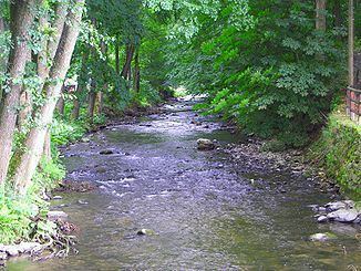
The Ölschnitz has its source at an impoundment and granite well stone in Solg, a village in the borough of Münchberg. It discharges into the White Main near Bad Berneck. The Ölschnitz flows from Solg through a wide valley to the village of Ölschnitz. It then flows down to Tennersreuth, passes under the A 9 motorway, supplies water for the Streitau Mill and continues to Böseneck. From here the little river snakes through an ever-narrower valley. After many bends it reaches the Entenmühle ("duck mill"), then flows around the hill spur near Stein in a large curve before cutting through the hard, diabase rock in a steep, rocky, narrow valley, rich in flora, and reaching the spa park (Kurpark) at Bad Berneck. After almost 19 km it discharges into the White Main. The Ölschnitz valley between the Entenmühle and Bad Berneck, through which the Westweg and Jean-Paul-Weg trails also run, is one of the most beautiful valleys in the Fichtelgebirge.
Economic utilisationEdit
Along the course of the stream, water power was used to drive many mill wheels. In 1536, the townsfolk of Berneck were giving fishing rights in the Ölsnitz and, in 1692, it was described as the "best trout stream in the Fichtelberge". In 1732, an ordinance concerning the Ölschnitz was issued by the Margrave of Bayreuth for the protection of the freshwater pearl mussels introduced there. Between 1733 and 1810, 6,000 pearls were harvested. Pearl fishing came under the supervision of a pearl inspector and, after 1810, the Bavarian Forestry Department.