
Time zone EET (UTC+2) Licence plate 06 Elevation 1,175 m Local time Sunday 3:54 AM | Region Central Anatolia Postal code 06xxx Website camlidere.gov.tr Area 650 km² Area code 0312 | |
 | ||
Weather -1°C, Wind NW at 5 km/h, 62% Humidity | ||
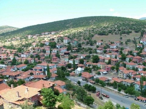
Çamlıdere is a town and district of Ankara Province in the Central Anatolia region of Turkey, 108 km north-west of the city of Ankara. According to 2010 census, population of the district is 7297 of which 2994 live in the town of Çamlıdere. The district covers an area of 633 km2 (244 sq mi), and the average elevation is 1,175 m (3,855 ft).
Contents
- Map of C387amlC4B1dere 06740 C387amlC4B1dere2FAnkara Turkey
- amldere today
- Places of interest
- References
Map of %C3%87aml%C4%B1dere, 06740 %C3%87aml%C4%B1dere%2FAnkara, Turkey
Çamlıdere was settled by the Seljuk Turks and there are a number of Seljuk period buildings in the area.
A large number of fossils and petrified forest have been found in the area.
Çamlıdere today
This is an attractive woodland district with lakes, meadows, a deer park, a scout camp and many other places for camping, walking and picnics. In summertime Çamlıdere is busy with day-trippers from Ankara and there is a growing number of guest-houses for weekenders coming to enjoy the fresh air and open skies. The people in this rural area are typically conservative and religious in outlook.
The summer festival in July features oil-wrestling, music, dance, circumcisions of boys, and pilgrimage to the tomb of Sheikh Ali Semerkandi.