
Discharge 485 m³/s Basin area 31,864 km² Mouth elevation 0 | Length 460 km | |
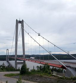 | ||
- average 500 m/s (17,657 cu ft/s) Bridges Höga Kusten Bridge, Sandö Bridge, Forsmo Bridge | ||
Olle l ngs ngermans o indals lven till stersund sveg siljan
The Ångerman or Angerman (Swedish: Ångermanälven) is one of Sweden's longest rivers with a total length of 460 kilometers (290 mi). It also has the third largest flow rate, after the Göta and Lule.
Contents
ngerman lven
Name
The name was formerly written Ångermann or Angermann. The name is derived from the Old Norse anger, which means "deep fjord" and appear as such in placenames in Norway and as "ånger" in placenames along the coast of Norrland.
Course
It starts in the Scandinavian mountain range in the southern parts of the Swedish province of Lapland. It then trails through Jämtland, increasing in power in the province of Ångermanland, whose name derives from it. The Vojmån, Fjällsjö, and Fax are its main tributaries. It contains an internal bifurcation Vängelälven.
It is navigable for about 50 miles (80 km) from the sea. Over the last 30 kilometers (20 mi) (after the town of Sollefteå noted on the map), it flows through a scenic valley known as Ådalen. The Ångerman then empties into the Baltic Sea's Gulf of Bothnia near the town of Kramfors.