
- summer (DST) CEST (UTC+2) Elevation 219 m Founded 12th century | Area 19.71 km² Local time Sunday 10:12 AM | |
 | ||
Weather 13°C, Wind W at 6 km/h, 72% Humidity | ||
esk brod m sto v pohybu 2016
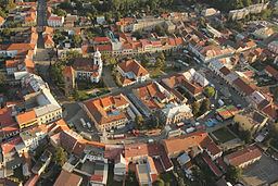
Český Brod ( [ˈtʃɛskiː ˈbrot]; German: Böhmisch Brod) is a town in the Central Bohemian Region of the Czech Republic. It is located 35 km east of Prague and had a population of 6,637 in 2005.
Contents
- esk brod m sto v pohybu 2016
- Map of 282 01 C48CeskC3BD Brod Czechia
- esk brod
- History
- Sightseeings
- Education
- References
Map of 282 01 %C4%8Cesk%C3%BD Brod, Czechia
Rock for People, an annual summer music festival, was held in Český Brod from 1995 to 2006. In 2007 it was decided to relocate this festival to Hradec Králové.
A large mediumwave broadcasting facility is located 2 km from the town at the village of Liblice, which is a part of Český Brod administrativelly.
esk brod
History
Český Brod was founded in the 12th century by Prague bishop John I. In 1286, it became a town. From that time till the beginning of the 14th century, the town's name was Biskupský Brod (Broda Episcopalis). In 1437, the Holy Roman Emperor Sigismund designated Český Brod a free royal town. Until 1918, the town was part of the Austrian monarchy (in the Austrian part of the empire after the compromise of 1867), head of the BÖHMISCH BROD - ČESKÝ BROD district, one of the 94 Bezirkshauptmannschaften in Bohemia. Český Brod is twinned with Southwell, Nottinghamshire UK.
Sightseeings
Education
In Český Brod, there are 3 kindergartens, 2 elementary schools, a school for students with special needs, a gymnasium, and a high school of economics (in Liblice).