
Population 0 | ||
 | ||
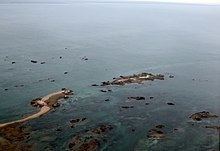
Major islands Maîtr'ÎleLa MarmotchiétheLé Bliantch'Île | ||
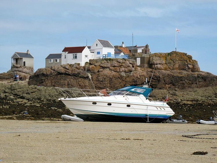
cr hous trip from jersey channel islands
The Écréhous (or Les Écréhou; in Jèrriais: Êcrého) are a group of islands and rocks situated six miles (9.6 km) north-east of Jersey, and eight miles (12.8 km) from France. They form part of the Bailiwick of Jersey and are administratively part of the Parish of St. Martin.
Contents
- cr hous trip from jersey channel islands
- Les cr hous mpeg
- Etymology
- Islets
- History
- Sovereignty
- Chapel and Priory
- Uses
- Long term residents
- Resolution of disputed status
- Invasions
- On currency
- Protected status
- Pilotage and sailing
- References
Les cr hous mpeg
Etymology
The name 'Écréhous' is Norse in origin. "Esker" as in Skerry meaning a stony bank and 'Hou', the toponym found also in Jethou, Lihou, Brecqhou, Burhou and other islets, derives from holm, meaning island. The first part of the name appears to be traced back to the Norse word sker, meaning reef. The Écréhous are actually, geologically, part of the same island group as Les Dirouilles (west) and Les Pierres de Lecq ('the Paternosters') (further west).
Islets
The most significant islets in the group are:
others include:
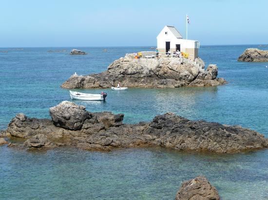
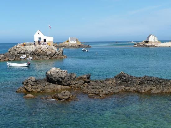
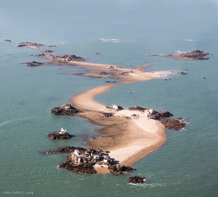
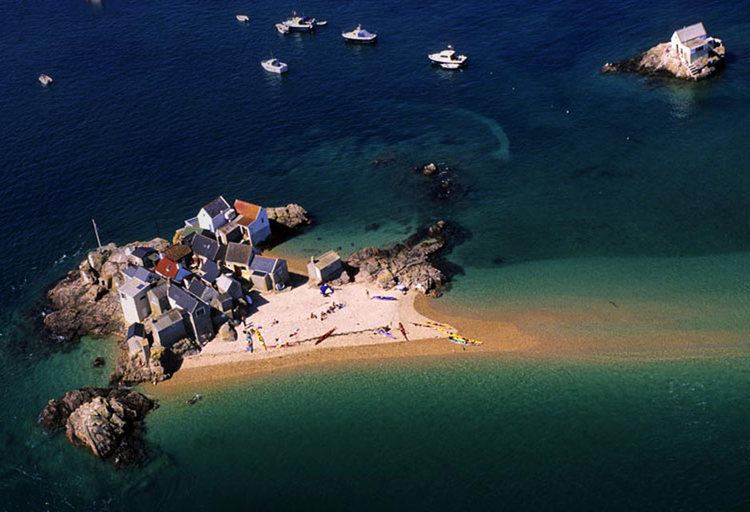
All but the three largest are submerged at high tide. There are no permanent residents on the islands and there is no fresh water there. Due to erosion, they are now much smaller than they may have been within historic times. Maîtr'Île, the largest of the islets, is about 300 metres (0.19 mi) long. There are a small number of fishermen's huts, some used as holiday residences, on the largest islets, and one official building, a customs house, on La Marmotchiéthe.
History
During the last Ice Age, sea levels were lower and the islands were high ground above a plain that connected the European Continent with southern England.
Sovereignty
The islets, along with the other Channel Islands and the Cotentin Peninsula, were annexed to the Duchy of Normandy in 933. After William, Duke of Normandy conquered England in 1066 the islands remained united to the Duchy until the conquest of mainland Normandy in 1204 by Philip Augustus. In 1259 Henry III did homage to the French king for the Channel Islands. While Edward III in the 1360 Treaty of Brétigny waived his claims to the crown of France and to Normandy, he reserved various territories to England.
Chapel and Priory
In 1203, shortly before the division of Normandy in 1204, John, Duke of Normandy granted the Écréhous to the Abbey of Val-Richer that they might build a church there. The chapel measured 10 feet 3 inches (3.12 m) in width and 16 feet 6 inches (5.03 m) in length; the priory accommodation for the monks formed an extension to the chapel. In 1309 it was reported that a prior was living in the Écréhous with one monk and a servant; a navigation light was lit every night.
In 1413 alien priories were suppressed, and the monks returned to Val-Richer. Their church and priory on La Maîtr'Île fell into ruins.
Uses
In the 17th century the Écréhous were used by smugglers. It was recorded that the main smuggled goods in the 1690s through the Écréhous was lead and gunpowder destined for St Malô.
In order to help control voting in Jersey, it was not unknown for citizens to find themselves taken and stranded on the Islands until after voting had taken place.
Long-term residents
Though they are only inhabited sporadically by holidaymakers and fishermen, in the past there have been more permanent residents on Les Écréhous due to more abundant vegetation. Two eccentrics who lived on the Écréhous for a long time proclaimed themselves to be Le Roi des Écréhous (The king of the Écréhous) and claimed that sovereignty over the islands belonged to them. Philippe Pinel lived on Bliantch'Île from 1848 to 1898 and exchanged gifts with Queen Victoria. In the 1960s and 1970s Alphonse Le Gastelois found refuge in the islands from unfounded public suspicion of being the Beast of Jersey (a notorious sexual attacker of children who was later arrested, thus clearing Le Gastelois of suspicion).
Resolution of disputed status
In the 19th and early 20th centuries there were several occasions on which nominal control was displayed - e.g. flags and buoys, and there were several occasions on which the British government indicated to the French government that it wished to settle the matter.
In 1950 Britain and France went to the International Court of Justice (ICJ) for friendly discussions to decide to which country the Minquiers and Écréhous belonged. The French fished in the waters, but Jersey exercised various administrative rights. Certain maps showed the Écréhous islands as not being part of Jersey. The ICJ considered the historical evidence, and in its Judgment of 17 November 1953 awarded the islands to Jersey.
'Invasions'
In 1993 and again in 1994, French 'invaders' from mainland Normandy landed on the Écréhous and raised Norman flags. This was done partly in protest against Channel Island fishing regulations and partly because they wanted the Écréhous to be recognised as part of France. The 1994 'invasion' was monitored closely by States and honorary police from Jersey, and the Union Flag that had been pulled down in 1993 was guarded by policemen. In the end, after only minor trouble being caused, the French had lunch on the islands before going back home. A priest who was part of the expedition said mass on the islands for the first time since the ruined abbey was in use (some hundreds of years). He created an outline of a church and altar using vraic he collected from the sea.
On currency
La Marmotchiéthe is depicted on the 2010 issue Jersey 50 pound note.
Protected status
In 2005, the States of Jersey designated it as an area under the Ramsar convention, signifying it was a wetland of international importance and giving it an enhanced status and recognition. A management plan for the area has yet to be published. There was a public consultation in 2010 into Jersey's management of Ramsar areas but the results were not made public.
Pilotage and sailing
Entrance to the island can be difficult. However, it is possible to visit at all states of tide with the main entrance from the southwest.