
Country Turkey, Georgia River mouth Black Sea Length 438 km Mouth Black Sea | Main source Mescid Mountains Basin area 22,100 km² Discharge 278 m³/s Countries Turkey, Georgia | |
 | ||
Basin size 22,100 km (8,500 sq mi) Similar Deriner Dam, Kaçkar Mountains, Yusufeli Dam, Parkhali, Kaçkar Dağı | ||
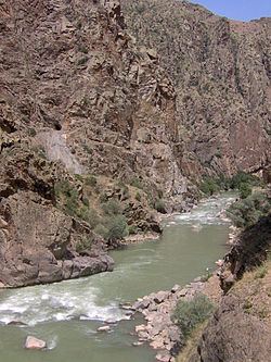
The Çoruh River (Turkish: Çoruh, Georgian: ჭოროხი ch'orokhi, Greek: Άκαμψις, Akampsis) rises in the Mescit Mountains in north-eastern Turkey, flows through the cities of Bayburt, Ispir, Yusufeli, and Artvin, along the Kelkit-Çoruh Fault, before flowing into Georgia, where it reaches the Black Sea just south of Batumi and a few kilometers north of the Turkish-Georgian border.
Contents
Map of Chorokhi
In Arrian's Periplus Ponti Euxini, it is called the Άκαμψις Acampsis; Pliny may have confused it with the Bathys. In English, it was formerly known as the Boas, the Churuk, or the Chorokh.
Biodiversity
The Çoruh valley lies within the Caucasus ecological zone, which is considered by the World Wild Fund for Nature and by Conservation International as a biodiversity hotspot. The Çoruh Valley is recognised by Turkish conservation organisations as an important plant area, an important bird area, a key biodiversity area and has been nominated as a high priority area for protection. This valley is rich in plants and contains 104 nationally threatened plant species of which 67 are endemic to Turkey.
Recreation
The Çoruh has been called "an eco-tourism gem" and "Turkey's last remaining wild river", and is being promoted for whitewater kayaking by the Eastern Anatolia Tourism Development Project. It attracts kayakers and rafters from all over the world and was the site of the 2005 Coruh Extreme kayak competition.
Dams
A total of 15 large hydroelectric dams are planned as part of the Çoruh River Development Plan but a total of 27 are proposed for the Çoruh River Catchment. Under the Çoruh Development Plan, 7 dams have been completed (Arkun, Artvin, Borçka, Deriner, Güllübağ, Murtli and Tortum Dams), another 3 are under construction.