Coat of arms Flag Population (2010 Census) 15,825 inhabitants Area 6 km² | Time zone MSK (UTC+03:00) Local time Sunday 3:14 AM | |
 | ||
Weather -13°C, Wind W at 16 km/h, 84% Humidity | ||
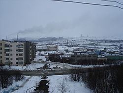
Zapolyarny (Russian: Заполя́рный) is a town in Pechengsky District of Murmansk Oblast, Russia, located on the Kola Peninsula, 10 kilometers (6.2 mi) northeast of the Kola Superdeep Borehole project. Population: 15,825 (2010 Census); 18,640 (2002 Census); 23,564 (1989 Census).
Map of Zapolyarny, Murmansk Oblast, Russia
The area where the town is located belonged to Finland in 1920–1944. It was founded in 1956 as Zhdanovsk (Жда́новск) and was granted work settlement status and later given its present name.
On February 1, 1963, by the Decree by the Presidium of the Supreme Soviet of the RSFSR, Zapolyarny was elevated in status to that of a town of district significance.
It is the nearest town to the former Koshka Yavr Airbase
References
Zapolyarny, Murmansk Oblast Wikipedia(Text) CC BY-SA
