
- elevation 1,131 ft (345 m) Length 32 km | - elevation 0 ft (0 m) | |
 | ||
Mouths | ||
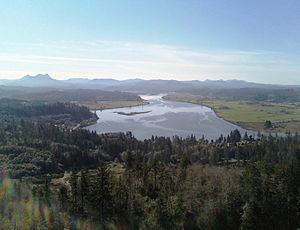
The Youngs River is a tributary of the Columbia River, approximately 27 miles (43 km) long, in northwest Oregon in the United States. It drains part of the Northern Oregon Coast Range in the extreme northwest corner of state, entering the Columbia via Youngs Bay just approximately 10 miles (16 km) from its mouth.
Map of Youngs River, Oregon, USA
It rises in a remote section of the mountains of central Clatsop County, north of Saddle Mountain State Natural Area. It flows generally northwest, passing over Youngs River Falls, discovered by a hunting party of the Lewis and Clark Expedition from nearby Fort Clatsop. It broadens in a large estuary and enters the south end of Youngs Bay on the Columbia at Astoria. It receives the Klaskanine River from the east approximately 5 miles (8 km) south of Astoria. It receives the Wallooskee River from the east approximately 2 miles (3 km) south of Astoria.
Named tributaries of Youngs River from source to mouth are Fall Creek and South Fork Youngs River, then Fox, Osgood, Rock, Bayney, Wawa, and Moosmoos creeks followed by the Klaskanine River. Below that come Cooperage, Battle Creek, Tucker, Casey, Binder, and Cook sloughs followed by the Wallooskee River. Further downstream are Crosel, Brown, and Craig creeks followed by Knowland Slough and the Lewis and Clark River.
About 13 miles (21 km) from the mouth of the river are Youngs River Falls, a 54-foot (16 m) tall waterfall.