
Postcode(s) 2681 Population 1,503 (2011 census) | Elevation 129 m (423 ft) Postal code 2681 | |
 | ||
Weather 19°C, Wind W at 27 km/h, 60% Humidity | ||
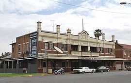
Yenda is a town in the Riverina district of New South Wales, Australia. The town is located about 16 kilometres (9.9 mi) east of Griffith, 65 kilometres (40 mi) north-west of Narrandera, and 550 kilometres (340 mi) west of Sydney in the Murrumbidgee Irrigation Area of southern New South Wales. Although most of the original 15-acre farms have been consolidated into large vineyards and most farmhouses have disappeared, farm roads are named after the original settlers. In 1940 Yenda had two clothing stores, two bakers, two butchers, two grocery stores, two barbers, one newsagency, one pharmacy, one cinema, one Greek restaurant and one bank but residents now do their shopping in nearby Griffith. At the 2011 census, Yenda had a population of 1,503.
Map of Yenda NSW 2681, Australia
The area forming part of Yenda is well covered by vineyards, which produce close to 70% of the wine for New South Wales. Rice paddies fed by the irrigation system also frequent the area as do stone and citrus fruit orchards, market gardens producing vegetables, and poultry farms.
Nearby is the 8,360-hectare (20,700-acre) Cocoparra National Park, containing waterfalls, gorges and bush walks and providing a home to over 150 species of birds.
The Yenda railway station, opened in 1916, lies on the Temora–Roto railway line and is now closed. Yenda Post Office opened somewhat later on 1 July 1919.