
Source Hlaing River | Mouth elevation 0 | |
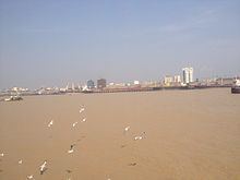 | ||
City Yangon also known as Rangoon | ||
The Yangon River (also known as Rangoon River or Hlaing River) is formed by the confluence of the Pegu and Myitmaka rivers and is a marine estuary that runs from Yangon (also known as Rangoon) emptying into the Gulf of Martaban of the Andaman Sea. The channel is navigable by ocean-going vessels and thus plays a critical role in the economy of Burma.
Map of Yangon River, Myanmar (Burma)
The Twante Canal connects the Yangon River with the Irrawaddy Delta or Ayeyarwady Delta, once known as 'the rice bowl of Asia'. It comprises 1,000 square miles (3,000 km2) of lush teak plantations and mangrove swamps, many of which have now been cleared in favour of rice production.
References
Yangon River Wikipedia(Text) CC BY-SA