
Country Japan Prefecture Yamanashi Prefecture - Tree Taxus cuspidata Local time Monday 10:42 AM | Region Chūbu
Tōkai District Minamitsuru Population 5,288 (1 Jul 2012) | |
 | ||
Time zone Japan Standard Time (UTC+9) Weather 7°C, Wind E at 3 km/h, 44% Humidity Points of interest Lake Yamanaka, Lake Yamanaka flower Cit, Yamanakako Exchange Plaza "Kir, Yamanakakohiranoonsen Ishiwari Hot Spring, Nagaike Water Park | ||
Yamanakako (山中湖村, Yamanakako-mura) is a village located in Minamitsuru District, Yamanashi Prefecture, Japan. As of July 2012, the village has an estimated population of 5,288 and a population density of 100 persons per km². The total area is 52.81 km².
Contents
- Map of Yamanakako Minamitsuru District Yamanashi Prefecture Japan
- Geography
- Neighboring municipalities
- History
- Economy
- Highway
- References
Map of Yamanakako, Minamitsuru District, Yamanashi Prefecture, Japan
Geography
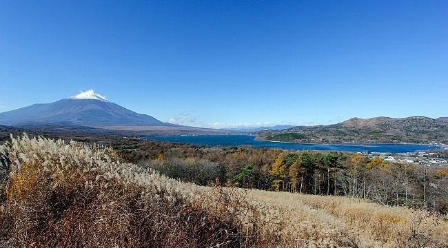
Yamanakako is located in the far southeastern corner of Yamanashi Prefecture, surrounding Lake Yamanaka. Much of the village area is protected forest, extending to the base of Mount Fuji, which is also visible from many locations.
Neighboring municipalities
Yamanashi Prefecture
Kanagawa Prefecture
Shizuoka Prefecture
History
Numerous Jōmon period remains have been found near Lake Yamanaka, and ancient Tsuru County, of which the area is a part, is mentioned in the late Nara period Engishiki records. The area was a contested border region between the Takeda clan, Imagawa clan and Odawara Hōjō clan during the Sengoku period.
During the Edo period, all of Kai Province was tenryō territory under direct control of the Tokugawa shogunate. During the cadastral reform of the early Meiji period in 1875, the village of Nakano was created within Minamitsuru District, Yamanashi Prefecture by the merger of Yamanaka and Hirano hamlets. This village was renamed Yamanakako Village on January 1, 1965.
Economy
The economy of Yamanakako is primarily based on tourism and agriculture.