
Time zone MST (UTC-7) Elevation 1,087 m Local time Thursday 12:47 AM | Incorporated June 22, 1906 Area code(s) 970 Zip code 80758 Population 2,390 (2013) | |
 | ||
Weather 4°C, Wind SE at 6 km/h, 57% Humidity | ||
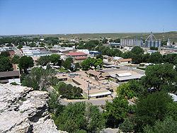
Wray (/ˈreɪ/) is a Home Rule Municipality that is the county seat of Yuma County, Colorado, United States. It is west from the Nebraska-Kansas state lines. The population was 2,342 at the U.S. Census 2010.
Contents
Map of Wray, CO 80758, USA
History
A post office called Wray has been in operation since 1882. The community was named after John Wray, a cattleman.
Wray was named an "All-America City" in 1993 by the National Civic League.
Geography
Wray is located at 40°4′36″N 102°13′33″W (40.076721, -102.225873), near the intersection of U.S. Highway 34 and U.S. Highway 385. According to the United States Census Bureau, the city has a total area of 3.0 square miles (7.8 km2), all land.
Climate
Wray has a semi-arid continental climate.
Demographics
As of the census of 2000, there were 2,187 people, 888 households, and 547 families residing in the city. The population density was 739.6 people per square mile (285.3/km²). There were 968 housing units at an average density of 327.4 per square mile (126.3/km²). The racial makeup of the city was 94.42% White, 0.09% African American, 0.27% Native American, 0.09% Asian, 3.48% from other races, and 1.65% from two or more races. Hispanic or Latino of any race were 10.01% of the population.
There were 888 households out of which 30.3% had children under the age of 18 living with them, 51.9% were married couples living together, 7.8% had a female householder with no husband present, and 38.3% were non-families. 35.1% of all households were made up of individuals and 18.5% had someone living alone who was 65 years of age or older. The average household size was 2.38 and the average family size was 3.11.
In the city, the population was spread out with 26.7% under the age of 18, 7.0% from 18 to 24, 24.6% from 25 to 44, 21.3% from 45 to 64, and 20.3% who were 65 years of age or older. The median age was 39 years. For every 100 females there were 88.7 males. For every 100 females age 18 and over, there were 85.1 males.
The median income for a household in the city was $29,052, and the median income for a family was $38,942. Males had a median income of $26,847 versus $19,250 for females. The per capita income for the city was $16,547. About 11.3% of families and 14.5% of the population were below the poverty line, including 14.8% of those under age 18 and 14.5% of those age 65 or over.
Education
The school mascot is the Eagles for high school and Eaglets in the lower grades. School colors are purple and white and the Eaglets were blue and white but were changed to purple and white to match the high school in 2011.
Health care
The town and surrounding area are served by the Wray Community District Hospital.