
Governing body National Park Service Management National Park Service | Area 36,740 km² Established 1980 | |
 | ||
Location Wrangell-Saint Elias National Park and Preserve, Alaska, United States | ||
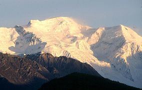
Wrangell–Saint Elias Wilderness is a wilderness area in Alaska, United States. At 9,078,675 acres (3,674,009 ha), it is the largest designated U.S. Wilderness Area, and lies within Wrangell–St. Elias National Park and Preserve, the largest national park in the United States. It is a land of remote valleys, wild rivers, and a fabulous wildlife population that includes Dall sheep, grizzly bears, black bears, coyotes, bison, caribou, wolverines, moose, beavers, mountain goats, gray wolves, red foxes, and marmots. In the north the glaciated peaks drop to tundra and boreal forested uplands. In the south massive glaciers spread from the mountains almost to the Gulf of Alaska. Several trails provide foot or horse access, but large braided rivers often stop progress unless a packraft is used. The classic route across the wilderness links the gold-rush era settlement of Chisana with the copper-mining era community of McCarthy, via 100 miles (160 km) of tundra, trails and gravel bars. Unmaintained trails lead through spruce forests near Chisana, across high tundra plains to the White River, below 16,000-foot (4,900 m) mountains over Skolai Pass, and into the Chitistone Gorge and Canyon with waterfalls to 1,500 feet (460 m) high. Mosquitoes are thick in the low country during the summer, and enough snow accumulates in the high country to make avalanches a year-round danger.
On the Canadian side of the border lies Kluane National Park, and together these two areas house some of the continent's most spectacular mountain landscapes.