
- land 16.2 sq mi (42 km) - summer (DST) EDT (UTC-4) Local time Wednesday 1:24 PM | - water 0.0 sq mi (0 km), 0% Population 7,789 (2000) | |
 | ||
Weather 17°C, Wind NW at 6 km/h, 48% Humidity | ||
Worcester Township is a township in Montgomery County, Pennsylvania, United States. The population was 9,750 at the 2010 census.
Contents
- Map of Worcester Township PA USA
- History
- Geography
- Neighboring municipalities
- Demographics
- Supervisors
- Legislators
- Trivia
- References
Map of Worcester Township, PA, USA
History
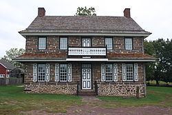
The Anthony Morris House and Peter Wentz Homestead are listed on the National Register of Historic Places.
Geography
According to the United States Census Bureau, the township has a total area of 16.2 square miles (42 km2), of which 0.06% is water. It is in the Schuylkill River watershed and is drained via Skippack Creek, which is a tributary of Perkiomen Creek, and Stony Creek. Its villages include Bethel Hill, Cedars, Fairview Village, Center Point, Heebnerville, Providence Square, and Worcester.
Neighboring municipalities
Demographics
As of the 2010 census, the township was 84.0% White, 2.8% Black or African American, 10.3% Asian, and 1.3% were two or more races. 1.6% of the population were of Hispanic or Latino ancestry.
As of the census of 2000, there were 7,789 people, 2,896 households, and 2,145 families residing in the township. The population density was 480.2 people per square mile (185.4/km2). There were 3,026 housing units at an average density of 72.0/km2 (186.6/mi²). The racial makeup of the township was 92.14% White, 2.32% African American, 0.03% Native American, 4.43% Asian, 0.00% Pacific Islander, 0.24% from other races, and 0.83% from two or more races. 0.87% of the population were Hispanic or Latino of any race.
There were 2,896 households, out of which 36.1% had children under the age of 18 living with them, 65.8% were married couples living together, 5.9% had a female householder with no husband present, and 25.9% were non-families. 23.1% of all households were made up of individuals, and 11.2% had someone living alone who was 65 years of age or older. The average household size was 2.69 and the average family size was 3.20.
In the township the population was spread out, with 27.3% under the age of 18, 4.6% from 18 to 24, 28.4% from 25 to 44, 24.3% from 45 to 64, and 15.3% who were 65 years of age or older. The median age was 40 years. For every 100 females there were 94.3 males. For every 100 females age 18 and over, there were 90.9 males.
The median income for a household in the township was $77,200, and the median income for a family was $87,107. Males had a median income of $61,280 versus $42,281 for females. The per capita income for the township was $34,264. About 0.5% of families and 1.7% of the population were below the poverty line, including 2.7% of those under age 18 and 3.3% of those age 65 or over.