
OS grid reference TQ235147 Region South East Sovereign state United Kingdom Area 8.49 km² District Horsham District UK parliament constituency Arundel and South Downs | Civil parish Woodmancote Country England Post town HENFIELD Shire county West Sussex Dialling code 01273 Postcode district BN5 | |
 | ||
Population 478 2001 Census; 543 (2011 Census) | ||
Woodmancote is a village and civil parish in the Horsham District of West Sussex, England, located 1 mile (1.5 km) southeast of Henfield on the A281 road. It should not be confused with the other West Sussex village of Woodmancote near Chichester.
Map of Woodmancote, UK
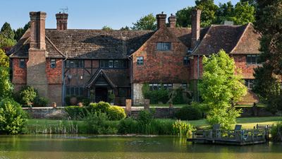
This scattered community has no village centre, but includes the hamlet of Blackstone. The Anglican parish church, St Peter's, stands alone beside the A281 road, while not far away is Woodmancote Place, a large house used as a country club. Originally thirteenth century the church was largely rebuilt in 1868. There is also a parish hall.
The parish was recorded in the Domesday survey of 1086 as Odemancote. Two of the Lewes martyrs, burnt at the stake in the Marian Persecutions of 1556, Thomas Harland and John Oswald, came from Woodmancote.
The parish has a land area of 849 hectares (2096 acres). In the 2001 census 478 people lived in 189 households, of whom 248 were economically active. At the 2011 Census the population was 543.