Samiksha Jaiswal (Editor)

Woodford, Northamptonshire

Updated on
Edit
Like
Comment
Share on FacebookTweet on TwitterShare on LinkedInShare on Reddit
Population
  
1,461 (2011 census)

Region
  
East Midlands

Sovereign state
  
United Kingdom

Dialling code
  
01832

Shire county
  
Northamptonshire

UK parliament constituency
  
Corby

OS grid reference
  
SP9676

Country
  
England

Post town
  
Kettering

Local time
  
Wednesday 1:58 PM

District
  
East Northamptonshire

Woodford, Northamptonshire

Weather
  
12°C, Wind NW at 16 km/h, 60% Humidity

Woodford is a large village and civil parish in East Northamptonshire, England. At the time of the 2011 census, the parish's population (including Woodwell) was 1,461 people.

Contents

Map of Woodford, UK

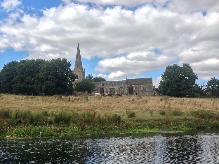
It is in two distinct parts, the easterly, lower, part being alongside the River Nene and the westerly, upper, part is on the through road out of the Nene valley. Its parish church is dedicated to St Mary the Virgin and has the nickname "the Cathedral of the Nene".

Inside the church can be found a couple of curiosities. Within a niche cut into a pillar, there is a mummified human heart wrapped in coarse cloth. This was discovered during restoration work in 1867. There is also a framed newspaper cutting; this concerns a photograph of an alleged ghost taken in the church in 1964.

Woodford House, an early 19th-century mansion, was the home of the Arbuthnot family and scene of the death of the diarist Harriet Arbuthnot in 1833. The property was purchased in 1880 by Charles Henry Plevins from Arthur Arbuthnot, son of General Charles Arbuthnot. The house was altered between 1899 and 1910 and had a new garden created in 1909. The Arbuthnots owned iron ore quarries on the estate which were dug from circa 1851, an early date for what was later to become a large industry in Northamptonshire.

Heritage assets

The following buildings and structures are listed by Historic England as of special architectural or historic interest.

  • Three Hills Round Barrows (Scheduled) Bronze Age 52.37368°N 0.58967°W / 52.37368; -0.58967
  • Bowl Barrow north of Woodford Mill (Scheduled) Bronze Age 52.37274°N 0.57113°W / 52.37274; -0.57113
  • Remains of Manor House and Garden (Scheduled) Unknown date 52.38249°N 0.57186°W / 52.38249; -0.57186
  • Medieval settlement remains (Scheduled) 9th century 52.37899°N 0.57961°W / 52.37899; -0.57961
  • Church of St Mary (Grade I) 12th century 52.38006°N 0.57729°W / 52.38006; -0.57729
  • Glebe Farmhouse (Grade I) 13th century 52.38030°N 0.57743°W / 52.38030; -0.57743
  • Wall with Finial south of Church of St Mary (Grade II) 14th century 52.37972°N 0.57723°W / 52.37972; -0.57723
  • Dovecote south of Manor Farmhouse (Grade II) 17th century 52.38090°N 0.58130°W / 52.38090; -0.58130
  • Manor House Farmhouse (Grade II*) 17th century 52.38090°N 0.58130°W / 52.38090; -0.58130
  • Woodford Rise (Grade II) 17th century 52.37971°N 0.57850°W / 52.37971; -0.57850
  • 50, 52 and 54 High Street (Grade II) 17th century 52.38279°N 0.58209°W / 52.38279; -0.58209
  • 84 High Street (Grade II) 17th century 52.38168°N 0.58104°W / 52.38168; -0.58104
  • Daventry Farmhouse and attached Outbuilding (Grade II) 17th century 52.38197°N 0.57986°W / 52.38197; -0.57986
  • Cheyham Cottage (Grade II) 17th century 52.38124°N 0.57608°W / 52.38124; -0.57608
  • Club Lane (Grade II) 18th century 52.38099°N 0.57802°W / 52.38099; -0.57802
  • Woodford Mill (Grade II) 18th century 52.36661°N 0.57155°W / 52.36661; -0.57155
  • 82 and Part of Number 84 over Carriage Arch (Grade II) 18th century 52.38181°N 0.58112°W / 52.38181; -0.58112
  • Woodford House, attached Cottages and Outbuildings (Grade II) 18th century 52.37724°N 0.61691°W / 52.37724; -0.61691
  • Olde Ways (Grade II) 18th century 52.38135°N 0.57811°W / 52.38135; -0.57811
  • Chest Tomb south of Church of St Mary (Grade II) 18th century 52.37988°N 0.57710°W / 52.37988; -0.57710
  • The Rectory (Grade II) 19th century 52.37926°N 0.57834°W / 52.37926; -0.57834
  • 72 and 74 High Street (Grade II) 19th century 52.38221°N 0.58142°W / 52.38221; -0.58142
  • The Round House and attached Barn (Grade II) 19th century 52.36407°N 0.62825°W / 52.36407; -0.62825
  • 70 High Street (Grade II) 19th century 52.38226°N 0.58154°W / 52.38226; -0.58154
  • War Memorial at Church of St Mary (Grade II) 20th century 52.38003°N 0.57751°W / 52.38003; -0.57751
  • War Memorial on The Green (Grade II) 20th century 52.38211°N 0.58100°W / 52.38211; -0.58100
  • Demography

  • In 1801 there were 491 persons
  • In 1831 there were 639 persons
  • In 1841 there were 680 persons
  • In 2011 there were 1,461 persons
  • References

    Woodford, Northamptonshire Wikipedia