
Length 40 km | ||
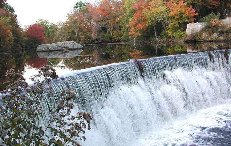 | ||
The Wood River is a river in the U.S. states of Connecticut and Rhode Island. It flows approximately 25 miles (40 km) and is a major tributary of the Pawcatuck River. There are 8 dams along the river's length.
Contents
Course
The Wood River's source is in the swamps northeast of Porter Pond in Sterling, Connecticut. From there, it flows southeast to Hazard Pond, where the river crosses into Rhode Island. From the state line, it flows southeast past Escoheag Hill and over Stepstone Falls, then south through Beach Pond State Park where it receives the Flat River.
After receiving the Flat River, the Wood continues south through the Arcadia Management Area and into the towns of Richmond and Hopkinton, where it flows through the villages of Wyoming and Hope Valley. The river continues south through Hopkinton where it converges with the Pawcatuck River at the village of Alton. The Wood River serves as the border between Richmond and Hopkinton.
The upper Wood River, from its source to Stepstone Falls, is known locally as the Falls River.
Major Source to the Community
The Wood River located in Southwestern Rhode Island is a protected and beneficial source of water to the Northeast Corridor. The Wood River is actually one of the last remaining pristine bodies of water of the Northeast between New York and Boston, the river being so pure is one of the main reasons the River is known by several people. According to the Wood-Pawcatuck Watershed Association, “The Pawcatuck Watershed provides drinking water to over 100,000 residents”. There are various laws that have been created in order to preserve this natural source. The Wood-Pawcatuck Watershed Association has a mission to protect the land and water of the Wood-Pawcatuck River from any pollution, such as boating, in order to protect the water sources for over ten towns. The River has been considered one of the most untouched for several years, and it is because of the Wood-Pawcatuck Water Association, WPWA, we can thank for this. The WPWA works to monitor the use of any non- electric powered boats entering the river, as this could be a huge pollution to the water. The Wood River is opposed to the use of any contaminating factors because so many people fish in the river and often eat the catch of the day, the water in the river is also used by not only the visiting but the residents that surround this area.
There are several access points along the river. Besides from being known for being one of the most pristine rivers along the Northeast, the Wood River's pure waters also offers a source for several other various activities and family fun in clean waters. The River is a huge traffic place for families during all times of the year in the Northeast. Many visitors come to this part of the Northeast, Rhode Island and Connecticut, to enjoy canoeing, kayaking, fishing, and even hiking along the waters edge. With traffic being so heavy along the river, it is important to preserve the river as much as possible. The cleanliness and fun at the river go hand in hand with one another.
Wood-Pawcatuck Watershed Association
The Wood-Pawcatuck Watershed Association is the main reason as to why the Wood River has remained so pure over the years. The River has been considered one of the most untouched for several years, and it is because of the Wood-Pawcatuck Water Association, WPWA, we can thank for this. The WPWA works to monitor the use of any non- electric powered boats entering the river, as this could be a huge pollution to the water. The Wood River is opposed to the use of any contaminating factors because so many people fish in the river and often eat the catch of the day, the water in the river is also used by not only the visiting but the residents that surround this area. The United States Environmental Protection Agency stated “The Pawcatuck Basin Aquifer System is the sole source of drinking water for the residents of that area; there are no viable alternative sources of sufficient supply; the boundaries of the designated area and project review area have been reviewed and approved by EPA; and if contamination were to occur, it would pose a significant public health hazard and a serious financial burden to the area's residents.”
Crossings
Below is a list of all crossings over the Wood River. The list starts at the headwaters and goes downstream.
Tributaries
In addition to many unnamed tributaries, the following brooks and rivers feed the Wood: