
Tracks 2 Opened 5 January 1952 Bicycle facilities 10 | Disabled access Yes Line(s) Blue Line Platforms in use 2 | |
 | ||
Location 450 Bennington Street
East Boston, Massachusetts Owned by Massachusetts Bay Transportation Authority Passengers (2013) 2,507 (weekday average boardings) Address Boston, MA 02128, United States Previous names Day Square(1952-1954); Wood Island Park (1954-1967) Owner Massachusetts Bay Transportation Authority Similar Suffolk Downs, Orient Heights, Maverick, Airport, Bowdoin | ||
Wood Island is a grade-level rapid transit station on the MBTA Blue Line, located off Bennington Street (Route 145) in the Day Square section of East Boston, Massachusetts. The station also serves as a bus transfer point for several local MBTA Bus routes.
Contents
The station is adjacent to the former Wood Island Park, a once heavily used recreational area for East Boston residents. Most of the park was destroyed in the mid 1960s to expand Logan International Airport.
Predecessor stations
The narrow gauge Boston, Revere Beach and Lynn Railroad (BRB&L) opened from East Boston to Lynn on July 29, 1875.
Wood Island station was located at Prescott Street in what was then the Wood Island neighborhood, approximately at 42°22′28.6″N 71°1′25.45″W. It opened along with the rest of the line on July 29, 1875. The station was abandoned when the BRB&L ceased operations in 1940, and demolished several years later during expansion of Logan Airport. The station site is now occupied by aviation support businesses.
Harbor View, the next station to the northeast, was located at Short Street at 42°22′51.36″N 71°0′58.14″W. Harbor View was a boxy station of identical design to Wood Island, though it was not an original station on the line and opened later than its twin. Located a short walk from Bennington Street, it lost much of its ridership to East Boston Tunnel trolleys, and was closed significantly sooner than the rest of the BRB&L. The building was sold, moved closer to Cowper Street, and converted to a private residence.
By 1928 the line was electrified, with pre-pay stations - more a rapid transit line than a conventional railroad. However, due to the Great Depression, the BRB&L shut down on January 27, 1940.
Rapid transit
In 1941, the Boston Elevated Railway bought the BRB&L right of way from Day Square to Revere Beach for use as a high-speed trolley line similar to the Ashmont-Mattapan High Speed Line; these plans were delayed by the onset of World War II. However, the 1926 Report on Improved Transportation Facilities and 1945–47 Coolidge Commission Report recommended that the East Boston Tunnel line, which had been converted to rapid transit from streetcars in 1924, be extended to Lynn via the BBRB&L route rather than using it for a trolley line.
In 1947, the newly formed Metropolitan Transit Authority (M.T.A.) decided to build to Lynn as a rapid transit line, and construction began in October 1948. The first part of the Revere Extension opened to Orient Heights on January 5, 1952, with intermediate stations at Airport Station and Day Square. Day Square station was built on a new section of right-of-way, which connected the former Eastern Railroad's East Boston Branch (used by the extension as far as Airport Station) with the BRB&L at Harbor View. The station was located between the former Wood Island and Harbor View stations, serving Day Square and the Neptune Road / Wood Island Park development designed by Frederick Law Olmsted.
Day Square station had its platforms at ground level, with an elevated busway for buses and trackless trolleys located above the platforms. A loop for these vehicles extended over a parking lot south of the station. The extension to Airport, Day Square, and Orient Heights opened on January 5, 1952, with further completion to Wonderland in 1954.
Day Square station was renamed Wood Island Park on October 21, 1954. In early 1967, as part of a series of station name changes, Wood Island Park was changed again to Wood Island, as Wood Island Park had been destroyed during the expansion of Logan Airport. The loop of the elevated busway was removed in the 1970s.
Modernization
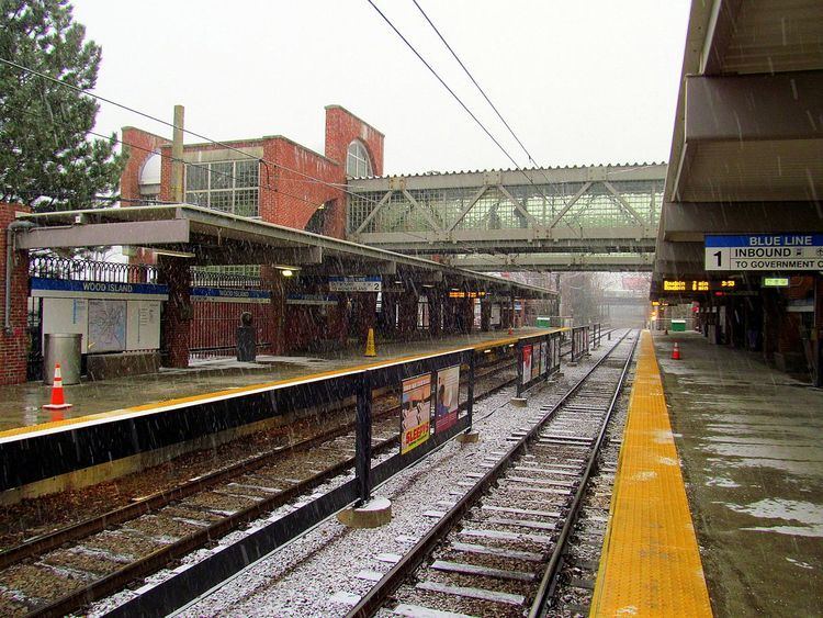
The Blue Line Modernization Project, which began in the 1990s and will continue until 2016, includes renovating stations to increase the length of trains from four to six cars, to make all stations wheelchair accessible, and to improve appearance. On June 25, 1994, the line was cut back to Orient Heights at all times to permit reconstruction of the outer stations. Beachmont and Wood Island were completely rebuilt, while Suffolk Downs, Revere Beach, and Wonderland were renovated. The busway, in poor shape from deferred maintenance, was removed in February 1994 and replaced with a surface busway north of the station, which is now fully open-air. The stations reopened on June 26, 1995. The station's two platforms on either side of two tracks are now connected by an overhead walkway within the paid zone.
Wood Island was closed from July 7 to September 5, 2008, for a renovation of both platforms. The platforms installed during the 1994 construction on the outer stations had not aged well, and were replaced during a series of short-term closures in 2008. Shuttle buses ran from Airport Station in lieu of subway service.
Bus connections
Three MBTA Bus routes stop at the Wood Island busway; the 112 and 121 routes terminate there.