
Postcode(s) 4275 | Postal code 4275 | |
 | ||
Wonglepong is a rural locality in the Scenic Rim Region of Queensland, Australia. At the 2011 Australian Census Wonglepong recorded a population of 367.
Contents
Map of Wonglepong QLD 4275, Australia
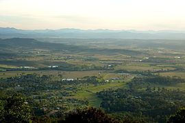
Wonglepong straddles a valley upstream from where Canungra Creek joins the Albert River. Development is centered along Beaudesert Nerang Road which passes through the lowest elevations. In the east the slopes of the valley rise sharply towards the Tamborine Mountain plateau.
History
The name Wonglepong was the name of the local railway station name from 1927 (previously known as Sarah Vale). Wonglepong is believed to be an Aboriginal name possibly meaning either forgotten sound or referring to some feature of Mount Tamborine.
There was a station at Wonglepong along the Canungra railway line, which operated from 1915 to 1955.
Heritage listings
Wonglepong has a number of heritage-listed sites, including: