Wombat is a town in South West Slopes region of New South Wales, Australia. It is situated on the Olympic Highway, 15 kilometres (9.3 mi) south-west of the regional centre of Young. It is in the local government area of Hilltops Council. Wombat has a population of approx 180.
The area was occupied by the indigenous Wiradjuri people for thousand of years.
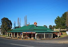
1860 - Gold discovered at nearby Young. 20,000 miners converge on surrounding areas. Wombat Post Office opened on 16 July 1862.1865 - The village of Wombat was established. Many Chinese miners moved to the area taking plots of land.1867 - Wombat Public School was founded in a bark hut1873 - foundation stone of St Matthews Church of England laid1875 - Roman Catholic Church built1877 - Wombat Hotel began trading1880 - Carlo Lazzarini, (1880-1952), NSW politician and trade unionist was born in Wombat.1895 - Mechanics Institute opened1903 - Wombat Hotel's current building constructed1909 - Roman Catholic convent opened1923 - Wombat Soldiers' Memorial hall officially opened1924 - the old hall was destroyed by fire1950s & 1960s - The Olympic Way highway was built through"The Wombat Hotel", which has had a continuous liquor licence since 1877, making it the longest in New South Wales."Allambie Orchard", A cherry orchard that allows people to pick their own fruit in season"Wombat Heights", a farm on a hill which produces jam, fruit wine and liqueurs from traditional recipes. Visitors are invited to do-it-themselves."Wilkies Cottage Restaurant/Café"."The Old Convent Geranium Nursery", Hope St, offers many colours & varieties of miniatures of variegated, climbing and scented Pelargonium geraniums.The highway into Wombat is graced with a statue of a wombat, made of local material, which was unveiled in 2002.