
Population 148 (2006 census) Elevation 964 m Local time Wednesday 1:21 PM | Postcode(s) 2350 Postal code 2350 | |
 | ||
Location 525 km (326 mi) N of Sydney38 km (24 mi) E of Armidale LGA(s) Armidale Dumaresq Shire Weather 15°C, Wind SE at 18 km/h, 70% Humidity | ||
Wollomombi is a small village situated 1 km north of Waterfall Way and approximately 38 kilometres east of Armidale, New South Wales, Australia. The settlement is at an altitude of about 964 metres on the Northern Tablelands in the New England region.
Contents
Map of Wollomombi NSW 2350, Australia
The village is centered between the Wollomombi River and Chandler River. These rivers fall into the Wollomombi Gorge about 4 km away at a site known as the Wollomombi Falls, which is in Oxley Wild Rivers National Park.
Wollomombi's population was 299 in the 1961 Census and has since fallen to 148 in the 2006 Census.
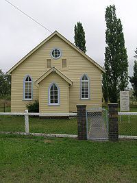
The village of Wollomombi comprises a general store, several houses, sports ground and a community hall. St John's Presbyterian Church, an original timber building, still stands in the village.
The dominant industry in the area is livestock grazing along with an expanding tourism industry.
The Chandler Public School is a small school of about 30 pupils that serves as Wollomombi’s school. This school is situated on the southern side of Waterfall Way, about 1.5 km from the village.
Wollomombi holds an annual rodeo in March and in October the village runs its annual Wood Expo.
History
Wollomombi Post Office opened on 1 August 1879.