
Country United States County Coconino Area code 928 Elevation 2,062 m Settled 1881 | Time zone MST (UTC-7) FIPS code 04-83160 Zip code 86046 Incorporated July 9, 1901 | |
 | ||
Weather 9°C, Wind SW at 18 km/h, 47% Humidity | ||
Williams arizona christmas 2016
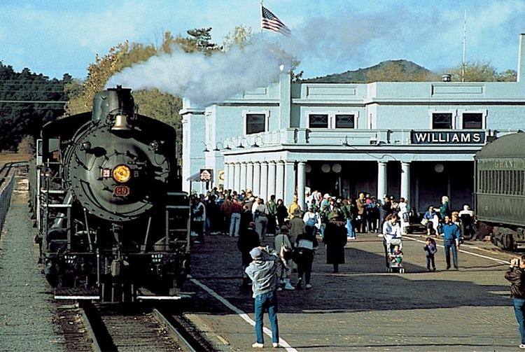
Williams (Havasupai: Wii Gvʼul) is a city in Coconino County, Arizona, west of Flagstaff. Its population was 3,023 at the 2010 census. It lies on the route of Historic Route 66, Interstate 40, and the Southwest Chief Amtrak train route. It is also the southern terminus of the Grand Canyon Railway, which takes visitors to Grand Canyon Village. There are numerous inns, motels, restaurants and gas stations that cater to the large influx of tourists rather than local residents, especially during the summer and holiday seasons.
Contents
- Williams arizona christmas 2016
- Map of Williams AZ 86046 USA
- History
- Demographics
- Geography
- Climate
- Government
- Education
- Transportation
- Notable people
- References
Map of Williams, AZ 86046, USA
Also known as the "Gateway to the Grand Canyon", Williams was the last town on Historic Route 66 to be bypassed by Interstate 40. The community, bypassed on Oct. 13, 1984, continues to thrive on tourism. Boasting seven area fishing lakes, hiking trails up Bill Williams Mountain and into Sycamore Canyon, an alpine ski area and cross country ski trails, four seasons weather and an abundance of wildlife, Williams offers unlimited recreational opportunities for the outdoor enthusiast.
The Historic Downtown District covers six square blocks. The town boasts a rich heritage that features the Old West and Route 66, coupled with tourism trends today and the town's heyday years of the '50s and '60s.
History
Williams is named after William "Old Bill" Williams, a mountain man and trader who often trapped in the area.
Founded in 1881, Williams was named for the famous trapper, scout and mountain man, "Old Bill Williams." A statue of "Old Bill" stands in Monument Park, located on the west side of the city. The large mountain directly south of town is named Bill Williams Mountain and the Town was incorporated July 9, 1901.
Williams was the last town to have its section of Route 66 bypassed, due to lawsuits that kept the last section of Interstate 40 in Arizona from being built around the town. After settlements called for the state to build three Williams exits, the suits were dropped and I-40 was completed. On October 13, 1984, Interstate 40 was opened around the town and newspapers the next day reported the essential end of US 66. The following year, Route 66 was decommissioned.
Williams Historic Business District and Urban Route 66, Williams were added to the National Register of Historic Places in 1984 and 1989, respectively.
Demographics
As of the census of 2000, there were 2,842 people, 1,057 households, and 733 families residing in the city. The population density was 65.3 people per square mile (25.2/km²). There were 1,204 housing units at an average density of 27.7 per square mile (10.7/km²). The racial makeup of the city was 77.13% White, 2.89% Black or African American, 1.72% Native American, 1.34% Asian, 0.04% Pacific Islander, 14.22% from other races, and 2.67% from two or more races. 32.34% of the population were Hispanic or Latino of any race.
There were 1,057 households out of which 36.2% had children under the age of 18 living with them, 51.1% were married couples living together, 13.3% had a female householder with no husband present, and 30.6% were non-families. 26.6% of all households were made up of individuals and 11.4% had someone living alone who was 65 years of age or older. The average household size was 2.69 and the average family size was 3.24.
In the city, the age distribution of the population shows 29.8% under the age of 18, 8.6% from 18 to 24, 28.3% from 25 to 44, 22.2% from 45 to 64, and 11.1% who were 65 years of age or older. The median age was 35 years. For every 100 females there were 103.4 males. For every 100 females age 18 and over, there were 96.4 males.
The median income for a household in the city was $32,455, and the median income for a family was $39,063. Males had a median income of $27,237 versus $25,162 for females. The per capita income for the city was $16,223. About 9.9% of families and 12.8% of the population were below the poverty line, including 18.2% of those under age 18 and 11.6% of those age 65 or over.
Geography
Williams is located at 35°14′58″N 112°11′24″W (35.249369, −112.189872) at 6,800 feet (2,100 m) in elevation. Bill Williams Mountain rises to an elevation of 9,256 feet (2,821 m) just south of Williams. According to the United States Census Bureau, the city has a total area of 43.8 square miles (113 km2), of which 43.5 square miles (113 km2) is land and 0.3 square miles (0.78 km2), or 0.66%, is water.
Climate
Williams has a cool-summer Mediterranean climate (Köppen Csb). On average in Williams, December is the coldest month, July is the warmest month, and August is the wettest month. The hottest temperature recorded in Williams was 102 °F (39 °C) in 1909; the coldest temperature recorded was −25 °F (−32 °C) in 1937.
Government
The City of Williams has adopted the Council-Manager form of government. The Williams City Council is the city’s legislative body. The seven member council oversee the operations of the city government and sets policy by approving programs, appropriating funds, enacting laws and appointing the City Manager and other officers such as the City Attorney, City Clerk and City Magistrate. Williams' Mayor and City Council are elected at large. The Mayor serves a two-year term and Council members serve overlapping four-year terms. The City Manager is appointed by, and serves at the pleasure of, the City Council and is responsible for overseeing the daily operations of the City. The role of the City Manager is to execute the policies and programs established by the City Council and to provide administrative leadership and management of municipal operations.
Federally, Williams is part of Arizona's 1st congressional district. Most recently it was represented by Republican Rick Renzi from 2003 to 2008, Democrat Ann Kirkpatrick following the 2008 election and Republican Paul Gosar following the 2010 election and again by Ann Kirkpatrick following the 2012 election.
Education
Williams is served by the Williams Unified School District. Two schools, Williams Elementary Middle School, and Williams High School, serve the city. A charter school, Heritage Elementary Charter School, also provides services.
Transportation
Amtrak, the national passenger rail system, provides daily service to Williams, operating its Southwest Chief between Chicago and Los Angeles. Rail passengers arrive and depart at Williams Junction, 3 miles (4.8 km) east of Williams, and are shuttled by Amtrak Thruway Motorcoach from Williams Junction to the Grand Canyon Railroad Station in downtown Williams.
The downtown station also serves as the southern terminus for the Grand Canyon Railway.
Williams also has a small General Aviation airport, H.A._Clark_Memorial_Field which serves small planes.