
Population 6 (2001 census) Anna Creek Anna Creek Local time Monday 5:08 PM | Time zone ACST (UTC+9:30) Anna Creek Anna Creek Elevation 521 m | |
 | ||
Location 852 km (529 mi) from Alice Springs1,000 km (621 mi) from Adelaide Lga Outback Communities Authority | ||
William Creek, Australia is located halfway on the Oodnadatta Track, 210 kilometres north of Marree and 166 kilometres east of Coober Pedy in South Australia. The town has a population of 6. William Creek is in the federal Division of Grey and the state electorate of Stuart. It is outside of council areas, and administered by the Outback Communities Authority.
Contents
Map of William Creek SA 5723, Australia
Location
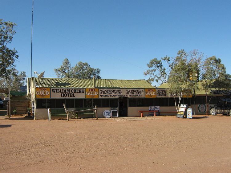
William Creek is the entry point from Coober Pedy to Lake Eyre in the Tirari Desert. William Creek offers the only petrol station between Marree, Coober Pedy and Oodnadatta on the Oodnadatta Track and has a campground, two motels and one of the world's most remote pubs. The world's largest cattle station is located in nearby Anna Creek Station and the Woomera Prohibited Area, former testing ground for atomic weapons, is also nearby.
William Creek is a good halfway stop along the track, with accommodation and meals at the Hotel as well as a well-maintained, if somewhat dusty campground. In the Memorial Park it is possible to see diverse items such as the first stage of the Black Arrow Rocket, Britain's only successful independent space launch that was recovered from the surrounding Anna Creek Station. More sobering is the commemorative inscription to a young Austrian woman, who lost her life in 1998 trying to walk back to William Creek from a 4WD vehicle bogged in the sand beside Lake Eyre.
William Creek is serviced twice weekly by the Coober Pedy Oodnadatta One Day Mail Run. The 4WD mail truck also carries some general freight and passengers.
History
William Creek was named in November 1859 by explorer John McDouall Stuart during his expeditions in the area. William was the second son of John Chambers, a pioneer pastoralist of South Australia and a strong ally of Stuart.
The town was once on The Ghan railway line.
The town has always been small: never larger than a few cottages, a small school and a Hotel-store.
The historic William Creek Hotel is listed on the South Australian Heritage Register.
Near William Creek
Lake Eyre can be seen from several vantage points along the Oodnadatta Track and appears as a large, rather featureless, white saltpan. It is only from the air that its immensity can be appreciated. The curvature of the Earth can be seen on the horizon and beneath it is possible to identify the courses of the ancient rivers that still occasionally flow into the lake. Trevor Wright and the pilots from Wrightsair take up to five passengers for a 60-minute flight out of William Creek, passing over the spectacular Painted Hills to the west, then along the southern edge of the lake, pointing out the features beneath and explaining the topography. The Painted Hills are brilliantly coloured eroded sandstone ridges. These, and all of the country traversed in the one-hour flight, are part of Anna Creek Station. From the air the Track can be seen, stretching to the horizon in two directions.