
OS grid reference SK034938 Post town GLOSSOP | Sovereign state United Kingdom Postcode district SK13 | |
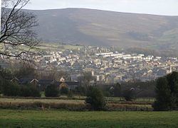 | ||
Whitfield is a hamlet in Derbyshire, England. It is located 1 kilometre (0.6 mi) south of Glossop town hall, south of Glossop Brook between Bray Clough and Hurst Brook. The urban area stretches about 1 kilometre (0.6 mi) up the hillside. Whitfield was one of the original townships in the ancient parish of Glossop, and in the manor. The ancient township rose from 150 to 544 metres (492 to 1,785 ft) above mean sea level, and the upper part is part of the Peak District National Park. The highest point is Mill Hill which is on the Pennine Way.
The Manor of Whitfield was conveyed in 1330 to John Foljambe. Though held with the manor of Glossop, the land in Whitfield was mostly not part of the Norfolk estate unlike most of the manor of Glossop. When it was enclosed by act of parliament in 1810 it was recorded as being 1,577 acres (6.38 km2). Included in Whitfield are the villages of Charlestown and Littlemoor.
The Turnlee Paper factory was in Littlemoor. St James, Littlemoor, was built in 1845 in the Early English style, with tower and 114-foot (35 m) spire. There is a Methodist Chapel at Whitfield; the Wesleyan Reformers and Independent Calvinists had chapels at Littlemoor.
When Glossop expanded, and the Howardtown Mills constructed, Whitfield was subsumed into the new town. Power looms were introduced into these mills in 1825. In 1835 Whitfield church was extended to take the increased congregation, and a Church of England Primary school was built in 1848; an infant school was added by Anne Kershaw Wood in 1913.