
- elevation 4,861 ft (1,482 m) - average 570 cu ft/s (0 m/s) Basin area 26,418 km² Mouth Missouri River Country United States of America | - elevation 1,601 ft (488 m) Length 933 km Discharge 16.14 m³/s Source Pine Ridge Bridges Stamford Bridge | |
 | ||
- location near Harrison, Dawes County, Nebraska - location near Chamberlain, Lyman County, South Dakota - max 51,900 cu ft/s (1,500 m/s) | ||
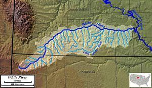
The White River is a Missouri River tributary that flows 580 miles (930 km) through the U.S. states of Nebraska and South Dakota. The name stems from the water's white-gray color, a function of eroded sand, clay, and volcanic ash carried by the river from its source near the Badlands. Draining a basin of about 10,200 square miles (26,000 km2), about 8,500 square miles (22,000 km2) of which is in South Dakota, the stream flows through a region of sparsely populated hills, plateaus, and badlands.
Contents
Map of White River, United States
The White River rises in northwestern Nebraska, in the Pine Ridge escarpment north of Harrison, at an elevation of 4,861 feet (1,482 m) above sea level. It flows southeast then northeast past Fort Robinson and north of Crawford. It crosses into southwestern South Dakota and flows north across the Pine Ridge Indian Reservation, then northeast, receiving Wounded Knee Creek and flowing between units of Badlands National Park. At the northern edge of the reservation, it flows east-northeast and southeast, forming the northern boundary of the reservation and the southern boundary of Buffalo Gap National Grassland. It receives the Little White River about 15 miles (24 km) south of Murdo, and flows east to join the Missouri in Lake Francis Case about 15 miles (24 km) southwest of Chamberlain.
The river sometimes has no flow, due to the dry climate surrounding its badlands and prairie basin, though thunderstorms can cause brief intense flow. The river near Chamberlain flows year-round. The White River has generally good-quality water.