
Length 80 m (260 ft) Highest elevation 15 m (49 ft) Elevation 15 m | Width 30 m (100 ft) Population 0 Area 1,600 m² | |
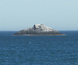 | ||
White Island is the name of two islands off the New Zealand coast. The smaller and less well known lies 2,500 metres (2,700 yd) off the coast of Otago, within the boundaries of the city of Dunedin.
Map of White Island, St Clair, Dunedin, New Zealand
The island is 80 metres (87 yd) in length and 30 metres (33 yd) wide at its widest point, covering 1,600 square metres (17,000 sq ft) and rising to a height of approximately 15 metres (49 ft). A rocky reef, parts of which break the surface at low tide, extends for 100 metres (110 yd) from the western end of the island.
The island is uninhabited, and is a well-known landmark visible from the city's two inner city beaches at St. Clair and St. Kilda.
The island's Māori name is Ponuiahine also given as 'Pomuiahine'. It has been translated, probably too literally, as 'The girl's great night' giving rise to witty suggestions as to why that might be. Goodall and Griffiths suggested it should be understood as 'Pou-nui-a-Hine, referring to a post being a memorial to some significant event involving Hine'. They observe 'Hine' can be a man's name but clearly this suggestion leaves open the original ribald speculations. As a place for a lovers' tryst it seems unpromising.
White Island may be the 'Ragged Rock' where the Sydney sealer Brothers, chartered by Robert Campbell and under the command of Robert Mason landed three men out of a gang of eleven in November 1809. William Tucker who later settled at Whareakeake (Murdering Beach), near Otago Heads, was in the gang. Alternatively Ragged Rock may be Green Island (Okaihe).
On May the first 1826 Thomas Shepherd, keeping a journal as he approached this coast as nurseryman to the first New Zealand Company's settlement expedition in the Rosanna, accompanied by the Lambton, said he 'saw two remarkable Sugar loaf Rocks in the sea near the shore about 100 feet (30 m) high'. A man was sent ashore and came back with a Māori man called Tatawa who 'said he belonged to Otago'. Shepherd later confirmed this was the part of the coast he was talking about. There is a reef south of White Island where the sea may be seen breaking. Presumably in the 1820s it too rose well above the sea. By the time of Dunedin's settlement in 1848 there was only the single island visible now.
Following the Russian scare in the early 1880s an Armstrong disappearing gun like the one still at Taiaroa Head was installed at Forbury Head above St. Clair. Apparently White Island was used for target practice which may have reduced it and made it more rugged than it was before.