
Country United States FIPS code 16-87310 Elevation 482 m Zip code 83554 Local time Saturday 9:17 PM | Time zone Pacific (PST) (UTC-8) GNIS feature ID 0398345 Area 18 ha Population 92 (2013) Area code 208 | |
 | ||
Weather 11°C, Wind SE at 6 km/h, 79% Humidity | ||
White Bird is a town in Idaho County, Idaho, United States. The population was 91 at the 2010 census.
Contents
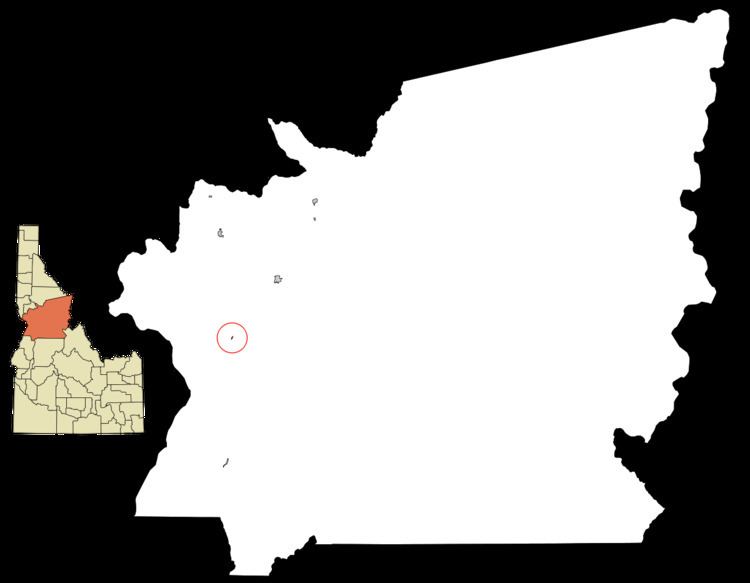
Map of White Bird, ID 83554, USA
History
At the southwest corner of the Camas Prairie, White Bird is near the Salmon River crossing point for the Lewis and Clark expedition. It is also the location of the 1877 Battle of White Bird Canyon, which was the first fight of the Nez Perce War and a significant defeat of the U.S. Army. Chief White Bird was a leader of the tribe. The summit of White Bird Hill is 2,700 feet (820 m) above the city, ascended via U.S. Highway 95.
White Bird was established 126 years ago in 1891, and was named for the Nez Perce chief.
Geography
White Bird is located at 45°45′40″N 116°18′6″W (45.761023, -116.301768).
According to the United States Census Bureau, the city has a total area of 0.07 square miles (0.18 km2), all of it land.
2010 census
As of the census of 2010, there were 91 people, 53 households, and 27 families residing in the city. The population density was 1,300.0 inhabitants per square mile (501.9/km2). There were 64 housing units at an average density of 914.3 per square mile (353.0/km2). The racial makeup of the city was 100.0% White. Hispanic or Latino of any race were 1.1% of the population.
There were 53 households of which 7.5% had children under the age of 18 living with them, 45.3% were married couples living together, 3.8% had a female householder with no husband present, 1.9% had a male householder with no wife present, and 49.1% were non-families. 41.5% of all households were made up of individuals and 13.2% had someone living alone who was 65 years of age or older. The average household size was 1.72 and the average family size was 2.26.
The median age in the city was 60.5 years. 5.5% of residents were under the age of 18; 3.3% were between the ages of 18 and 24; 5.5% were from 25 to 44; 52.8% were from 45 to 64; and 33% were 65 years of age or older. The gender makeup of the city was 51.6% male and 48.4% female.
2000 census
As of the census of 2000, there were 106 people, 59 households, and 31 families residing in the city. The population density was 1,623.7 people per square mile (584.7/km²). There were 73 housing units at an average density of 1,118.2 per square mile (402.6/km²). The racial makeup of the city was 97.17% White, 0.94% Native American, and 1.89% from two or more races. Hispanic or Latino of any race were 1.89% of the population.
There were 59 households out of which 6.8% had children under the age of 18 living with them, 47.5% were married couples living together, 3.4% had a female householder with no husband present, and 45.8% were non-families. 39.0% of all households were made up of individuals and 11.9% had someone living alone who was 65 years of age or older. The average household size was 1.80 and the average family size was 2.31.
In the city, the population was spread out with 12.3% under the age of 18, 3.8% from 18 to 24, 11.3% from 25 to 44, 46.2% from 45 to 64, and 26.4% who were 65 years of age or older. The median age was 53 years. For every 100 females there were 116.3 males. For every 100 females age 18 and over, there were 116.3 males.
The median income for a household in the city was $18,558, and the median income for a family was $21,042. Males had a median income of $21,667 versus $25,000 for females. The per capita income for the city was $10,819. There were 10.8% of families and 21.2% of the population living below the poverty line, including 40.0% of under eighteens and none of those over 64.