
Sovereign state United Kingdom Postcode district S35 | Post town SHEFFIELD Local time Saturday 5:17 PM Dialling code 0114 | |
 | ||
Weather 12°C, Wind W at 16 km/h, 70% Humidity | ||
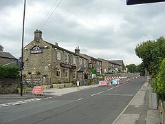
Wharncliffe Side is a village in South Yorkshire, England, northwest of Sheffield and within the city borough.
Map of Wharncliffe Side, Sheffield, UK
Wharcliffe Side is located on the west bank of the River Don, approximately 10 km northwest of Sheffield city centre, and 1 km northwest of Oughtibridge, south of the confluence of the Ewden beck and the River Don. The A6102 road passes through the village.
The village has a population of 1355 (2011), and is a commuter village for Sheffield and Stocksbridge. The village is within the Stocksbridge and Upper Don electoral ward. There is a primary school on Brighthomelee Lane, along with a post office and two public houses within the village. Glen Howe Park is situated at the southern end of the village. The ancient farming hamlet of Brightholmlee lies 0.5 km to the west.