
Country United States County Lincoln FIPS code 23-84135 Elevation 21 m Population 718 (2010) Area code 207 | Time zone Eastern (EST) (UTC-5) GNIS feature ID 0582810 Zip code 04578 Local time Saturday 9:09 AM | |
 | ||
Weather 1°C, Wind NE at 13 km/h, 92% Humidity Area 36.88 km² (22.82 km² Land / 14.06 km² Water) | ||
Westport Island, formerly Westport, is a town in Lincoln County, Maine, United States. In the 19th Century the island was known as Jeremysquam, a nickname islanders still use for it. The population was 718 at the 2010 census.
Contents
Map of Westport, ME 04578, USA
Geography
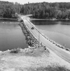
Westport Island is located approximately 50 miles northeast of Portland, Maine. The island is separated from the mainland by two coastal salt-water rivers, the Sheepscot River and the Back River. The island is connected to the mainland at the Northwest by one modern bridge, built in 1972 over a slim gap in the Back River called Cowsegan Narrows. Although completely surrounded by water, it is bounded across tidal water by the towns of Wiscasset, Edgecomb, Southport, and Georgetown.
According to the United States Census Bureau, the town has a total area of 14.24 square miles (36.88 km2), of which, 8.81 square miles (22.82 km2) of it is land and 5.43 square miles (14.06 km2) is water.
2010 census
As of the census of 2010, there were 718 people, 329 households, and 227 families residing in the town. The population density was 81.5 inhabitants per square mile (31.5/km2). There were 535 housing units at an average density of 60.7 per square mile (23.4/km2). The racial makeup of the town was 97.8% White, 0.1% African American, 0.3% Native American, 0.3% Asian, 0.4% from other races, and 1.1% from two or more races. Hispanic or Latino of any race were 1.0% of the population.
There were 329 households of which 21.0% had children under the age of 18 living with them, 57.4% were married couples living together, 6.7% had a female householder with no husband present, 4.9% had a male householder with no wife present, and 31.0% were non-families. 23.1% of all households were made up of individuals and 9.4% had someone living alone who was 65 years of age or older. The average household size was 2.18 and the average family size was 2.48.
The median age in the town was 52 years. 15.2% of residents were under the age of 18; 4% were between the ages of 18 and 24; 20% were from 25 to 44; 36.9% were from 45 to 64; and 24% were 65 years of age or older. The gender makeup of the town was 49.9% male and 50.1% female.
2000 census
As of the census of 2000, there were 745 people, 318 households, and 228 families residing in the town. The population density was 85.2 people per square mile (32.9/km²). There were 510 housing units at an average density of 58.3 per square mile (22.5/km²). The racial makeup of the town was 98.26% White, 0.13% African American, 0.67% Native American, and 0.94% from two or more races.
There were 318 households out of which 26.1% had children under the age of 18 living with them, 62.9% were married couples living together, 6.3% had a female householder with no husband present, and 28.0% were non-families. 24.2% of all households were made up of individuals and 8.8% had someone living alone who was 65 years of age or older. The average household size was 2.33 and the average family size was 2.74.
In the town, the population was spread out with 22.4% under the age of 18, 3.1% from 18 to 24, 24.7% from 25 to 44, 32.6% from 45 to 64, and 17.2% who were 65 years of age or older. The median age was 45 years. For every 100 females there were 98.1 males. For every 100 females age 18 and over, there were 100.7 males.
The median income for a household in the town was $39,010, and the median income for a family was $42,625. Males had a median income of $32,426 versus $27,647 for females. The per capita income for the town was $21,623. About 5.2% of families and 6.6% of the population were below the poverty line, including 7.6% of those under age 18 and 7.5% of those age 65 or over.
Economics
Fishing is a principal employer for residents of Westport Island, as with much of this part of Maine. Fishermen are most commonly involved in the trapping of lobster and crabs for sale in the local fish markets. Other resources gathered include groundfish, scallops, shrimp, clams, mussels, quaohogs, and bloodworms. Other local employers include the Bath Iron Works, a large shipyard where Aegis class Destroyers are built for the US Navy. Many local residents are also involved in cottage industry and building construction services for other town residents.
The median household income is $39,010 and the median family income is $42,625. Approximately 12.4% of the population lives under the poverty line.