Neha Patil (Editor)

Westmead, New South Wales

Updated on
Edit
Like
Comment
Share on FacebookTweet on TwitterShare on LinkedInShare on Reddit
Population
  
14,171 (2011 census)

State electorate(s)
  
Seven Hills Granville

Postal code
  
2145

Postcode(s)
  
2145

Westmead
  
Parramatta

Federal division
  
Division of Parramatta

Westmead, New South Wales httpsuploadwikimediaorgwikipediacommonsbb

Location
  
26 km (16 mi) west of Sydney

Lga
  
City of Parramatta Council

Westmead is a suburb of Sydney, in the state of New South Wales, Australia. Westmead is 26 kilometres (16 mi) west of the Sydney central business district, in the local government areas of the City of Parramatta and Cumberland Council; and is part of the Greater Western Sydney region.

Contents

Map of Westmead NSW 2145, Australia

Geography

Westmead is bounded by the Parramatta River, Toongabbie Creek and Finlayson Creek in the north. On the east it is bounded by Parramatta Park, the Parramatta Golf Club, Amos Street and Good Street. The southern boundary is the Great Western Highway. The western boundary is Bridge Road, the railway line and Finlayson Creek.

History

With the British settlement of Parramatta, Westmead was originally part of the domain of Government House. What is left of this domain, including Government House, form Parramatta Park. The name Westmead came into use when the governor's domain was first subdivided in 1859. The subdivision of the domain was completed in 1889. The Northern Meadow and Western Meadow of the domain were split off and called Northmead and Westmead. From this time orchards were established by many new settlers, including some whose names were well known in the Parramatta area - George Oakes, Nat Payten and William Fullagar among them.

Parramatta Marist School was established by Fr. John Therry in Hunter Street Parramatta in 1820, under the direction of Mr. George Morley. The school was transferred to the site of the present junior school in 1837 and entrusted to the care of the Marist Brothers in 1875. This makes Parramatta Marist the oldest Catholic school in Australia.

Health

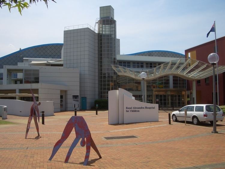
Health is the major employer in the area, with large public hospitals for both adults and children, a mental health hospital, a private hospital and three medical research facilities spanning basic, genetic and molecular science for both adults and children. A community foundation supports fundraising and awareness activities of Westmead.

  • CareFlight, an adult medical retrieval service
  • Children's Medical Research Institute
  • Cumberland Hospital, a psychiatric hospital
  • NETS, an intensive care service for neonates
  • The Children's Hospital at Westmead (also called the Royal Alexandra Hospital for Children or Sydney Children's Hopital Network, Westmead)
  • Westmead Centre for Oral Health
  • Westmead Hospital, a major teaching hospital, which was opened in November 1978
  • Westmead Medical Research Foundation
  • Westmead Millennium Institute for Medical Research
  • Education

  • University of Western Sydney (UWS).
  • UWS College, Westmead Campus.
  • Westmead Public School was established in 1917, when an Infants' School opened in a rented Church of England hall in April of that year. By 1919 the present site was acquired, and the first purpose-built school building was opened in May 1920. In 1923 the building was extended to provide accommodation for Primary students. Within two years the growing local population created demand for additional accommodation for Primary students. At the present day Westmead Public School is one of the best primary schools in NSW, with high academic, sporting and art achievements. It schools over 900 children and has many professional teachers and staff.
  • The Catherine McAuley Catholic High School is an all Girls school located on the same campus as Parramatta Marist High School
  • Parramatta Marist High School is the oldest Catholic school in Australia, established in 1820.
  • Sacred Heart Primary School
  • Westmead Christian Grammar School (formerly Essington Christian Academy) was established at the site of Essington House in 1983. It provides a Christian Education for students from Kindergarten through to Year 6. [1]
  • Transport

    Westmead railway station is on the North Shore, Northern & Western Line of the Sydney Trains network.

    The Western railway line from Parramatta to Blacktown was built through the suburb in 1861. A railway station at Westmead was opened in April 1893 after a successful petition by local residents.

    A bus transitway, the North-West T-way, services Westmead from both Parramatta and The Hills District.

    The two-line Parramatta Light Rail project was announced in 2015. Westmead will be the terminus of both lines, which will operate to Carlingford and Strathfield.

    On the day of the 2011 census, 39% of employed people traveled to work on public transport and 43% by car (either as driver or as passenger).

    Demographics

    At the 2011 census, the suburb of Westmead recorded a population of 14,171. Of these:

  • Age distribution: Residents were notably younger than the country overall. The median age was 31 years, compared to the national median of 37 years. Children aged under 15 years made up 19.5% of the population (national average is 19.3%) and people aged 65 years and over made up just 8.1% of the population (national average is 14.0%).
  • Ethnic diversity : Just under one-third (30%) were born in Australia, compared to the national average of 70%; the next most common countries of birth were India 30%, China 6%, and Sri Lanka 4%. At home, 26% of residents only spoke English; other languages spoken at home included Hindi 8.8%, Gujarati 7.7%, Tamil 6.4%, Mandarin 5.3% and Telugu 5.1%.
  • Finances: The median household weekly income was $1,475, slightly more than the national median of $1,234. This minor difference is also reflected in real estate prices, with the median mortgage payment in Westmead being $2,000 per month, compared to the national median of $1,800.
  • Transport: On the day of the Census, 39% of employed people traveled to work on public transport and 43% by car (either as driver or as passenger).
  • Housing: More than two-thirds (68%) of occupied private dwellings were flats, units or apartments; 20% were separate houses, and 12.5% were semi-detached (row or terrace houses, townhouses etc.). The average household size was 2.6 people.
  • Religion: The most common religious affiliations were Hinduism 33%, Catholic 16%, No Religion 11%, and Islam 8%.
  • References

    Westmead, New South Wales Wikipedia