
Country United States Incorporated May 18, 1885 Elevation 409 m Zip code 72774 Area code 479 | Founded 1848 Time zone Central (CST) (UTC-6) Area 8.5 km² Population 2,468 (2013) Local time Friday 6:06 PM | |
 | ||
Weather 19°C, Wind NE at 8 km/h, 52% Humidity | ||
West Fork is a city in Washington County, Arkansas, United States. The population is 2,317 at the 2010 census. It is part of the Fayetteville–Springdale–Rogers, AR-MO Metropolitan Statistical Area.
Contents
- Map of West Fork AR 72774 USA
- History
- Geography
- Demographics
- Parks and recreation
- Education
- Media
- Notable people
- References
Map of West Fork, AR 72774, USA
History
West Fork was incorporated as a city on May 18, 1885.
Geography
West Fork is located at 35°55′57″N 94°10′57″W (35.932618, -94.182539). According to the United States Census Bureau, the city has a total area of 3.3 square miles (8.5 km2), all of it land.
Demographics
As of the census of 2000, there were 2,042 people, 750 households, and 600 families residing in the city. The population density was 612.8 people per square mile (236.8/km²). There were 800 housing units at an average density of 240.1 per square mile (92.8/km²). The racial makeup of the city was 94.56% White or European American, 0.44% Black or African American, 0.93% Native American, 0.54% Asian, 1.71% from other races, and 1.81% from two or more races. 3.13% of the population were Hispanic or Latino of any race.
There were 750 households out of which 41.2% had children under the age of 18 living with them, 63.3% were married couples living together, 12.1% had a female householder with no husband present, and 19.9% were non-families. 16.4% of all households were made up of individuals and 7.6% had someone living alone who was 65 years of age or older. The average household size was 3.72 and the average family size was 4.04.
In the city, the population was spread out with 30.0% under the age of 18, 8.1% from 18 to 24, 30.2% from 25 to 44, 21.8% from 45 to 64, and 9.8% who were 65 years of age or older. The median age was 33 years. For every 100 females there were 96.9 males. For every 100 females age 18 and over, there were 92.1 males.
Economically one of the poorer regions of the Northwest Arkansas region, the median income for a household in the city was $31,356, and the median income for a family was $34,818. Males had a median income of $28,037 versus $20,091 for females. The per capita income for the city was $14,976. About 34.6% of families and 25.8% of the population were below the poverty line, including 28.3% of those under age 18 and 19.7% of those age 65 or over.
Parks and recreation
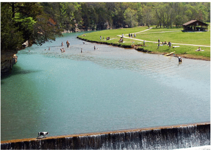
The White River cuts the town of West Fork in half. The town sits on the west fork of the White River, hence the name. Alongside the river is Riverside Park, a common spot for recreational activities such as parties and reunions. The park features playground equipment, several pavilions, many benches, and a walking path. The town is flanked by mountains on both the east and west with Bloyd Mountain on the east being over 2,000 ft. in elevation.
Education
West Fork Public Schools serves the city, and includes:
All of the West Fork schools are co-located on School Avenue, west of the White River. West Fork's official school mascot is a tiger.
Media
West Fork is the home of the Washington County Observer newspaper.