
Elevation 335-475 m (−1,220 ft) Area 4.7 km² Dialling code 7472 | Time zone CET/CEST (UTC+1/+2) Postal code 72108 Administrative region Tübingen | |
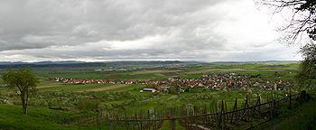 | ||
Wendelsheim is a suburban district of Rottenburg am Neckar in the administrative district of Tübingen in Baden-Württemberg (Germany).
Contents
- Map of 72108 Wendelsheim Germany
- Geography
- Extent
- Neighbour localities
- Population
- Faiths
- Sister village
- References
Map of 72108 Wendelsheim, Germany
Geography
Wendelsheim is located 4 km (2.5 mi) northern from Rottenburg and 11 km (6.8 mi) southwestern from Tübingen.
Extent
The area of the district is 470 hectares. Thereof fall 71.0% upon agriculturally used area, 15.1% upon forest area, 13.6% upon settlement area and roads, 0.2% upon water expanse and 0.2% upon other.
Neighbour localities
The territories of the following localities adjoin to Wendelsheim, they are called clockwise beginning in the north: Oberndorf, Wurmlingen, Rottenburg (town), Seebronn. All bordering localities are in the administrative district of Tübingen, and all are part of the Town of Rottenburg.
Population
Wendelsheim has 1555 inhabitants (31/01/08). It is one of the largest suburbs of Rottenburg. At an area of 4.70 km² (1.8 sq mi) this corresponds to a population density of 331 people per km², or 857 per sq mi.
Faiths
The population is predominantly Roman Catholic.