
Country South Africa Municipality Drakenstein Postal code (street) 7655 Area 15.69 km² Local time Monday 3:39 AM | District Cape Winelands Established 1840 PO box 7654 Province Western Cape | |
 | ||
Weather 17°C, Wind N at 11 km/h, 81% Humidity Points of interest Goodnow Hall, Wellington Museum, Wellington Wines Taste Ro, Bosman Family Vineyard | ||
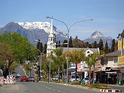
Wellington is a town in the Western Cape Winelands, a 45-minute drive from Cape Town, in South Africa with a population of approximately 62,000. Wellington's economy is centered on agriculture such as wine, table grapes, deciduous fruit and a brandy industry. The town is located 75 km north-east of Cape Town, reached by the N1 motorway and R44. Due to the growth of the Mbekweni township south of town, it now forms a de facto urban unit with Paarl, just 10 km to the south.
Contents
Map of Wellington, 7655, South Africa
Location
Wellington is situated at the foot of the Groenberg on the banks of the Kromme Rivier (Dutch for Bend River) and forms the center of the Cape Winelands with its picturesque environment and numerous wineries.The town is at the base of one of the oldest mountain passes in the country, Bain's Kloof Pass, built by master road-builder Andrew Geddes Bain. The town is the home of the Boland Rugby Union and the professional rugby team the Boland Kavaliers. The town is also an academic centre, with Cape Peninsula University of Technology, the Timothy Ministry Team, Bible Media, Huguenot High School and Weltevrede Senior Secondary School, Bergriver Senior Secondary School amongst others.
Etymology
There were two attempts to name Wellington. Sir George Napier suggested that the town should be named after ’England’s greatest soldier’. In 1840 the town of Wellington was proclaimed after the Duke who defeated Napoleon at Waterloo. The erstwhile name of the 'dorp' (Dutch/Afrikaans for village) was Wagenmakersvallei, meaning, Wagon makers' valley (Valley of the wagon makers), or Val du Charron as the French Huguenots called it.
Coats of arms
Municipality (1) — Wellington was a municipality in its own right from 1873 to 2000. On 18 June 1918, the town council adopted a pseudo-heraldic design as the municipal arms. The shield was blue, and contained a landscape scene in a circular border. The shield was supported by two red lions, each with a golden coronet around its neck (these being the supporters of the arms of the Duke of Wellington). The arms were depicted on a cigarette card issued in 1931.
Municipality (2) — On 22 June 1948, the council approved a new coat of arms, designed by Ivan Mitford-Barberton and H. Ellis Tomlinson. This was in response to a Cape Provincial Administration circular calling on municipalities to have their arms checked and, if necessary, re-designed to make them heraldically correct. The arms were registered at the Bureau of Heraldry in February 1987.
The design reflected the town's Huguenot origins : Per chevron Argent and Azure, in chief two hurts, each charged with a fleur-de-lis Or, in base a Huguenot cross, Argent (in layman's terms : the shield is divided into silver over blue by a chevron-shaped line, in the upper half are two golden fleurs de lis on blue discs and in the lower half is a silver Huguenot cross). A blue mural crown was added as a crest. The existing supporters were retained, but were differenced by adding a silver anchor to the coronet. The motto was "Par foi et loyaute".