
City Washington, D.C. Basin size 11,500 acres (47 km) Basin area 46.54 km² Country United States of America | River system Potomac River Length 8 km Mouth Anacostia River | |
 | ||
County Prince George's County, Maryland River mouth Anacostia River; 38°54′21″N 76°57′26″W / 38.905706°N 76.957115°W Coordinates: 38°54′21″N 76°57′26″W / 38.905706°N 76.957115°W | ||
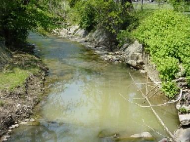
Watts Branch is a tributary stream of the Anacostia River in Prince George's County, Maryland, and Washington, D.C.
Contents
Map of Watts Branch, Washington, DC, USA
CourseEdit
The headwaters of the stream originate in the Capitol Heights area of Prince George's County, and the branch flows roughly northwest for 4.9 miles (7.9 km) to the Anacostia, which drains to the Potomac River and the Chesapeake Bay. The watershed area of Watts Branch is about 6,000 acres (24 km2) in Prince George's County and 5,500 acres (22 km2) in Washington.
Water qualityEdit
Watts Branch is in a highly urbanized area, and its water quality has been rated as poor by government agencies. The stream has been polluted by urban runoff (stormwater), dumped trash and leaking sewer pipes. Much of the stream is in concrete channels or culverts. A variety of stream cleanup and restoration projects have been initiated by D.C. government, the United States Environmental Protection Agency (EPA) and other federal agencies, in cooperation with community organizations such as the Anacostia Watershed Society and the Watts Branch Community Alliance.