
Length 33 km (21 mi) Season all year round | Location Palatine Forest Trail difficulty easy | |
 | ||
Lowest point ca. 300 m, powder mill near Schopp | ||
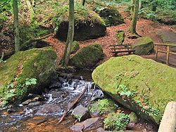
The Waterway trail on the Moosalbe (German: Gewässerwanderweg an der Moosalbe) is one of seven themed walks on the subject of hydrology in the German state of Rhineland-Palatinate. The path runs for over 33 km along the Moosalbe and Hirschalbe streams through the Palatine Forest and has 23 way stations.
Documentation by the State Ministry for the Environment and Forests describes the route and gives detailed information on the geology, hydrology und climate of the area.
Route
The following significant water management stations connected with mills, weirs, wells, springs, waterbodies and ecosystems lie on the route:
- Klug'sche Mühle, a mill with weir and mill pond
- Fischweiher source (source of the Karlstal)
- Fish breeding ponds
- Unterhammer, with a weir for driving the iron hammer mill
- Hummocky meadow (Buckelwiesen), an irrigation scheme
- Weir (Stauwehr)
- Iron smelting (Eisenschmelz)
- Stelzenberg Waterworks and spring
- Friends of Nature house of Finsterbrunnertal
- Rolling mill (Walzwerk)
- Borehole (Tiefbrunnen) III
- Engtalbach waterway management (Gewässerausbau) near Krickenbach
- Old Pumphouse (Altes Pumpwerk) in the parish of Schopp
- Natural section of the Moosalbe near Schopp
- Powder mill pond (Pulvermühlweiher)
- Powder mill (Pulvermühle), ruins of the old factory that produced black powder
- Hirschalb valley and mill (Hirschalbtal and Hirschalbmühle)
- Source of the Moosalbe
- Tiefenteich spring
- Submerged spring (Grundquelle), near Tiefenteich
- Langspateliges Laichkraut
- Oberhammer Waterworks with Boreholes 1 and 2 (near Trippstadt)
- Karlstal Gorge with its cave house and the Amseldell
References
Waterway trail on the Moosalbe Wikipedia(Text) CC BY-SA