
Population 3,378 (2006) | Northwest (Waitemata Harbour) | |
 | ||
Waterview is a suburb of Auckland City, located along the western side of Auckland's isthmus. Its boundaries are Oakley Creek in the east, Heron Park in the south, the Waitemata Harbour (and Motu Manawa (Pollen Island) Marine Reserve) in the west, and the Northwestern Motorway and the Oakley Creek inlet in the north.
Contents
Map of Waterview, Auckland 1026, New Zealand
Waterview is primarily a residential area, with its residents commuting to work. There are few shops: a dairy, laundromat, bakery, and a community-owned cafe. Community facilities are available at Point Chevalier or Avondale, 20–30 minutes walk away.
History
The Waterview area, especially along the coast and inlet areas, has a relatively high incidence of archeologically significant areas, from old settlement remnants (both Maori and early European settler), to a comparatively well-retained site of an old mill/tannery and quarry (Star Mill/Garret Bros Tannery) which is scheduled as a Category I Historic Place, and which once used the stream waters to drive a waterwheel.
The population of Waterview has grown:
Transport
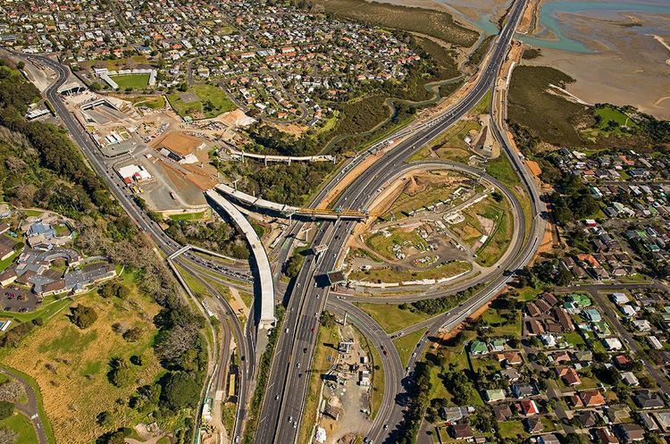
The major issue facing Waterview is the construction of SH20 from Hillsborough through to the Northwestern Motorway. The route through Waterview was highly contentious until (and to a degree after) a fast-tracked Board of Inquiry process consented a route in mid-2011, which will place a new motorway tunnel portal and motorway interchange at the north end of the suburb, causing the removal of numerous homes in the area.
Public transport facilities from Waterview allow access to a range of destinations in Auckland City, and a shared walking and cycling path is proposed to link Waterview with Mt Albert and several other suburbs along the State Highway 16 cycle route.
Education
Waterview Primary School has a student roll of about 150, and a Decile 2 rating.
There is no secondary school in the suburb; nearby state secondary schools include Avondale College, Western Springs College and Mount Albert Grammar School.