
 | ||
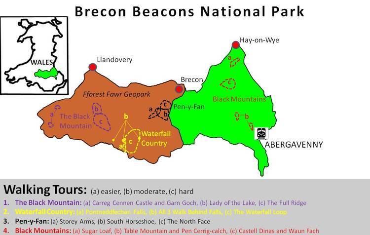
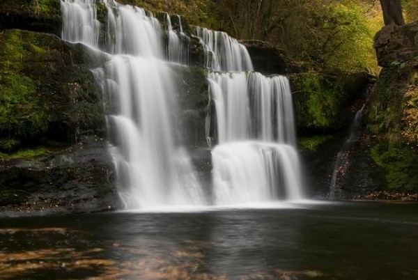
Waterfall Country (or sometimes Waterfalls Country) is the name given to an area around the head of the Vale of Neath in South Wales where an unusually large number of publicly accessible falls are to be found. The area is loosely defined but generally includes the group of falls on the Nedd Fechan, Pyrddin, Hepste and Mellte rivers, all of which lie in the country between the villages of Pontneddfechan and Ystradfellte in the southern part of the Brecon Beacons National Park. All of these falls lie within or on the boundary of the county of Brecknockshire, now part of the unitary authority of Powys. A few miles further west are Henrhyd Falls on the Nant Llech, a tributary of the Tawe and to the southwest are Melin Court Falls on the Melin Court Brook, a tributary of the River Neath. These, along with Aberdulais Falls on the Dulais, a further tributary of the Neath are also encompassed by the term 'Waterfall/s Country' by some writers.
Contents
- Origins
- Sgwd Clun gwyn
- Sgwd Isaf Clun gwyn
- Sgwd y Pannwr
- Sgwd yr Eira
- Sgwd Ddwli Uchaf
- Sgwd Ddwli Isaf
- Sgwd y Bedol
- Sgwd Gwladus
- Sgwd Einion Gam
- Sychryd Cascade
- Henrhyd Falls
- Aberdulais Falls
- Melincourt Falls
- Information and interpretation for visitors
- References
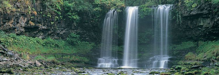
Collectively the falls are one of the most popular natural attractions in South Wales, a fact which has brought about problems of erosion in the vicinity of many of the falls. Most occupy locations designated as sites of special scientific interest or as special areas of conservation which aim to protect the biodiversity and geodiversity of these sites. The designations place a duty on the landowners and managers to protect the sites and so various erosion control measures have been put in place in an attempt to counter the worst problems.
Origins
Virtually all of the falls occur on tributaries of the River Neath occupying valleys that have been deeply incised into the landscape. It is suggested that overdeepening of the Vale of Neath by glacier ice during the succession of ice ages has resulted in these tributaries cutting down into their own beds as they adjust to a base level lower than in pre-glacial times. The underlying geology is a generally southerly dipping succession of Carboniferous age sandstones and mudstones assigned by geologists to the Marros Group and formerly referred to as the Millstone Grit Series. Preferential erosion, whereby the less resistant mudstones have been more readily removed by the passage of water, often following various forms of weathering, has left sandstones forming the lips of the falls. The siting of individual falls is closely linked in many cases to the presence of northwest–southeast–aligned faults that have brought different lithologies into proximity.
Sgwd Clun-gwyn
The 'fall of the white meadow' is the uppermost of the three celebrated falls on the Mellte. It is formed where a north-northwest to south-southeast trending fault brings hard sandstone up against softer mudstone.
Sgwd Isaf Clun-gwyn
The 'lower fall of the white meadow' is the middle of three falls.
Sgwd y Pannwr
The 'fall of the fuller' or 'fall of the woollen washer' is the lowermost of the three celebrated falls on the Mellte.
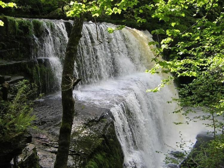
Sgwd yr Eira
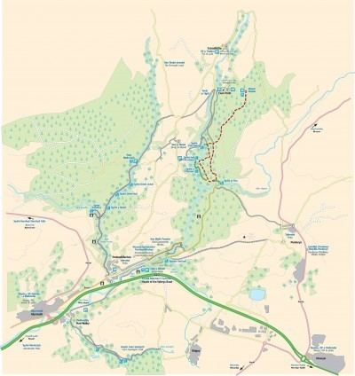
Famous for being the falls behind which you can walk, the 'falls of snow' plunge over a hard band of sandstone whose overhang protects the walker from the full force of the water. The closure of the path behind this most popular of falls during much of 2007 and 2008 on safety grounds was controversial. Stabilisation works agreed between the landowners, the Forestry Commission, the Countryside Council for Wales and the Brecon Beacons National Park Authority allowed the route to be re-opened later in 2008. For a walk taking in Sgwd Clun-gwyn, Sgwd Isaf Clun-gwyn and Sgwd yr Eira see 'Waterfall Walk' under Ystradfellte.
Sgwd Ddwli Uchaf
The 'upper gushing falls' are spectacular.
Sgwd Ddwli Isaf
The 'lower gushing falls' are also spectacular.
Sgwd y Bedol
The 'horseshoe falls' which are in fact a series of three or four falls in quick succession.
Sgwd Gwladus
The 'Lady's Falls' are formed where the Afon Pyrddin drops 20 ft (6 m) over a lip of the 'Twelve Foot Sandstone'. The lady concerned was one of the many daughters of Brychan, the 5th-century King of Brycheinog. The sandstone tilts gently to the south so forcing the waters of the Pyrddin up against the foot of a high cliff of mudstone and over the left-hand side of the rock lip (when viewed from below). In higher water conditions the fall gradually extends further to the right. The upper surface of the sandstone is roughly patterned with the fossil roots of trees. A rocking stone (now dislodged) sits on this bench some 50 metres (160 ft) north of the falls.
Sgwd Einion Gam
Associated in legend with the 'lady' of Sgwd Gwladus, the 'fall of crooked Einion' is one of the most spectacular though least accessible of the falls of the area. The river drops 70 ft (21 m) into a plunge pool encircled by dark moss- and liverwort-covered cliffs. The falls have been created where the Pyrddin drops off the faulted edge of the Farewell Rock, a hard sandstone marking the base of the Carboniferous Coal Measures. The falls are difficult of access with only a rough path reaching them from the vicinity of Sgwd Gwladus downstream and requiring several tricky crossings of the river.
Sychryd Cascade
The waters of Sychryd are here confined between the rocky walls of Craig-y-Ddinas (Dinas Rock) on the one hand and those of Bwa Maen (Stone Bow) on the other. Thought not a single fall, the tumbling of the river over a jumble of rocks in its bed at this spot is sometimes referred to as the Sychryd Cascade or Sgydau Sychryd. This rocky slot has been eroded by the river along the line of the Neath Disturbance, a heavily faulted zone extending northeast to southwest. Tramways approach both from above and below and there was formerly a substantial metal ramp constructed over the cascades linking the two levels though this has long since been removed after it fell into disuse and became a safety hazard.
More falls occur in the section of the river above the cascade. These falls can be viewed from the north bank which is publicly accessible. A further small fall at Pwll y Crochan near where the A465 Heads of the Valleys Road crosses the river though this spot is not accessible to the public.
Henrhyd Falls
The Nant Llech rises on the southern slopes of Carreg Cadno and flows to the village of Coelbren at which point it drops 90 feet (27 m) over the lip of a faulted block of the Farewell Rock, a hard sandstone. This spectacular site and section of the gorge below the falls is owned and managed by the National Trust. The waterfall is referred to in Welsh as Sgwd Henryd or as Rhaeadr Henryd.
Aberdulais Falls
The Dulais rises near the coalmining town of Aberdulais/Seven Sisters and flows for several miles to join the waters of the River Neath at Aberdulais. The falls are set only 160 yards (150 metres) up the river from that confluence (at OS grid ref SS772995) and are readily accessible from the A465 road which runs the length of the Vale of Neath. Not only is this a spectacular fall but also an important industrial heritage site which is now in the care of the National Trust.
Melincourt Falls
Melin Court Brook rises on the high ground to the southeast of Resolven in the Vale of Neath. It drops from the plateau surface above 450 metres (1,480 ft) above sea level to the floor of the Vale of Neath at around 30 metres (98 ft) in the space of just under 5 kilometres (3.1 mi). Several falls occur over its course but the single big drop of 80 feet (24 m) at Melincourt (OS grid ref SN826016) is the most spectacular and has drawn visitors for over 200 years since it was painted by Turner in 1794.
The falls (otherwise known as Melincwrt Falls), can be viewed from above, where a minor public road bridges the brook immediately upstream of the drop, and from below by means of a footpath which runs up beside the brook from the B4334 road between Melincourt village and Resolven.
The falls are contained within a 13-acre (5 ha) nature reserve managed by the Wildlife Trust of South and West Wales. Neath Port Talbot County Borough Council provide car parking beside the road at the start of the path up the falls.
Information and interpretation for visitors
The Brecon Beacons National Park Authority established a visitor centre at Pontneddfechan in 2008 making use of a building previously used by Neath Port Talbot County Borough Council as a tourist information centre. Renamed as the Waterfalls Centre, it is staffed throughout the year to provide information for visitors to Waterfall Country, the wider national park and the Fforest Fawr Geopark. The Authority announced it was to close permanently on 6 June 2016.
The National Trust operate a centre at Aberdulais Falls which performs a similar role.