
Country United States County Wayne Established April 20, 1829 Zip code 14568 | State New York Settled 1799 Elevation 571 ft (174 m) Population 9,449 (2010) | |
 | ||
Weather 4°C, Wind SW at 14 km/h, 60% Humidity | ||
Walworth is a town in Wayne County, New York, United States. The population was 9,449 at the 2010 census. The name comes from Reuben Walworth, a state official.
Contents
- Map of Walworth NY 14568 USA
- History
- Geography
- Demographics
- Housing
- Communities and locations in the Town of Walworth
- References
Map of Walworth, NY 14568, USA
The Town of Walworth is on the west border of the county and is east of Rochester, New York. It has a hamlet, also called Walworth. Government offices for the town are located there.
History
The town was first settled in 1799 when four brothers named Andrew, John, Samuel, and Daniel Millet left their homes in Connecticut, traveled west and became the first settlers in what is now the hamlet of Walworth. There they built crude log cabins, the first dwellings in Walworth.
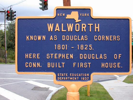
Stephen and Daniel Douglas, also from Connecticut, located in this area in 1800. Stephen Douglas built the first frame house on the southwest corner of the present four corners of the hamlet of Walworth. Soon after, they gave their name to this growing community and for a number of years it was known as Douglas Corners.
The Town of Walworth was created in 1829 from the Town of Ontario, the last town formed in Wayne County.
Theron Yeomans of Walworth introduced Holstein cattle to the United States and was the first president of the Holstein-Friesian Association of America. Susan Cleveland, sister of President Grover Cleveland married into the Yeomans family.
In 1934, a freeze killed many of the town's orchards, leading to a sharp decline in fruit growing.
Geography
According to the United States Census Bureau, the town has a total area of 33.9 square miles (88 km2), of which, 33.8 square miles (88 km2) of it is land and 0.04 square miles (0.10 km2) of it (0.12%) is water.
The west town line is the border of Monroe County.
New York State Route 350 and New York State Route 441 intersect in the town. New York State Route 286 is another east-west highway, paralleling and north of NY-441, also ending at NY-350.
Demographics
As of the census of 2010, there were 9,949 people, 3,356 households, and 2,694 families residing in the town. The population density was 278.7 people per square mile (107.7/km²). The racial makeup of the town was 96.5% White, 0.9% Black or African American, 0.1% Native American, 0.8% Asian, 0.0% Pacific Islander, 0.3% from other races, and 1.4% from two or more races. Hispanic or Latino of any race were 1.9% of the population.
There were 3,356 households out of which 40.2% had people under the age of 18 living with them, 69.0% were married couples living together, 7.2% had a female householder with no husband present, and 19.7% were non-families. 15.0% of all households were made up of individuals and 5.0% had someone living alone who was 65 years of age or older. The average household size was 2.81 and the average family size was 3.14.
In the town, the population was spread out with 30.4% under the age of 20, 3.6% from 20 to 24, 26.6% from 25 to 44, 30.6% from 45 to 64, and 8.7% who were 65 years of age or older. The median age was 39.5 years. For every 100 females there were 99.3 males. For every 100 females age 18 and over, there were 98.0 males.
The median income for a household in the town was $76,146, and the median income for a family was $85,181. Males had a median income of $64,392 versus $41,594 for females. The per capita income for the town was $29,551. About 1.0% of families and 2.7% of the population were below the poverty line, including 2.3% of those under age 18 and 0.8% of those age 65 or over.
Housing
There were 3,486 housing units at an average density of 102.8 per square mile (39.7/km²). 3.7% of housing units were vacant.
There were 3,356 occupied housing units in the town. 3,093 were owner-occupied units (92.2%), while 263 were renter-occupied (7.8%). The homeowner vacancy rate was 0.7% of total units. The rental unit vacancy rate was 12.9%.
Communities and locations in the Town of Walworth
School Districts Walworth is served by Wayne Central School District and Gananda School District.