
OS grid reference TA282006 Post town Grimsby | Sovereign state United Kingdom Postcode district DN36 | |
 | ||
Waithe (or Waythe) is a hamlet and civil parish in the East Lindsey district of Lincolnshire, England. It is situated on the A16, 1 mile (1.6 km) south from Holton-le-Clay and 1 mile (1.6 km) north from North Thoresby.
Map of Waithe, Grimsby, UK
In the Domesday account Waithe is written as "Wade", and was one of the 398 properties assigned to Ilbert of Lacy.
The village is the site of a deserted medieval village, indicated by earthworks, trackways and ditch enclosures, and 13th- to 18th-century pottery finds.
In 1885 Kelly's Directory reported that agricultural production in the then 780 acres (3.2 km2) parish was chiefly wheat, oats, turnips and barley, farmed under a four-field system.
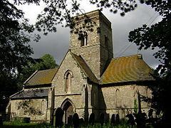
Waithe Grade I listed redundant church is dedicated to St Martin. The church was rebuilt in 1861 by James Fowler of Louth, leaving only the Early English nave arcades and tower as elements of an earlier Saxon cruciform church. The church was repaired and conserved in 2005.
Other listed structures include Grade II Waithe Water Mill, dating from 1813.