
Country New Zealand District New Plymouth District | Region | |
 | ||
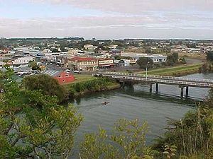
Map of Waitara, New Zealand
Waitara is a town in the northern part of the Taranaki region of the North Island of New Zealand. Waitara is located just off State Highway 3, 15 kilometres (9.3 mi) northeast of New Plymouth. Its population was 6312 in the 2013 census, an increase of 24 from 2006.
Contents
- Map of Waitara New Zealand
- Houses for rent in new plymouth nz waitara house 3br2ba by property management new plymouth
- Waitara 2 bdrm house
- History and conflict
- Land confiscations
- Economy
- Education
- References
Waitara was the site of the outbreak of the Taranaki Wars in 1860 following the attempted purchase of land for English settlers from its Māori owners. Disputes over land that was subsequently confiscated by the Government continue to this day.
The commonly accepted meaning of the name Waitara is "mountain stream", though Maori legend also states that it was originally Whai-tara—"path of the dart". In 1867 the settlement was named Raleigh, after Sir Walter Raleigh. It reverted to its former name with the establishment of the borough of Waitara in 1904.
Houses for rent in new plymouth nz waitara house 3br2ba by property management new plymouth
Waitara 2 bdrm house
History and conflict
Prior to European colonisation, Waitara lay on the main overland route between the Waikato and Taranaki districts. Vestiges of numerous pā on all strategic heights in the district indicate close settlement and closely contested possession, just before and in early European times, by various tribes. Whalers and sealers, who had come from the northern hemisphere, gained help from and formed relationships with local Māori in the early 19th-century, but the area was largely vacated in the 1820s and 1830s following warfare between the resident Te Atiawa iwi (tribe) and those of iwi from north Auckland down to the Waikato. Some Te Atiawa were taken to Waikato as prisoners and slaves, but most migrated to the Cook Strait area in pursuit of guns and goods from whalers and traders.
Pākehā settlers who came to New Plymouth (founded in 1841) in the 1840s and 1850s viewed nearby Waitara as the most valuable of Taranaki's coastal lands because of its fertile soil and superior harbour. The New Zealand Company drew up plans for settlement from New Plymouth to beyond Waitara, and sold blocks to immigrants despite a lack of proof that the company’s initial purchase of the land had been legitimate. The company claimed that Te Atiawa had either abandoned the land or lost possession of it, owing to conquest by Waikato Māori. (The Land Claims Commission later upheld this view, but subsequently Governor Robert FitzRoy (in office 1843-1845) rejected it, as did the Waitangi Tribunal in 1996.)
Tensions between settlers and local Māori began as early as July 1842, when settlers who had taken up land north of the Waitara River were driven from their farms. A year later 100 men, women and children sat in a surveyors' path to disrupt the surveying of land for sale.
Between March and November 1848 Wiremu Kīngi, a Te Atiawa chief who staunchly opposed the sale of land in the Waitara area, returned to the district from Waikanae with almost 600 men, women and children and some livestock to retake possession of the land. They established substantial cultivations of wheat, oats, maize and potatoes, selling it to settlers and also for export; his followers also laboured on settler farms. The Waitangi Tribunal noted that the group allegedly eventually owned 150 horses and up to 300 head of cattle.
Despite Kingi's opposition however, payments were made by government agents secretly to Maori individuals for prospective sales of land in the Waitara area, prompting spates of violence between those supporting and opposing land sales.
In 1857 the issue came to a head with the offer for sale of land at Waitara and at Turangi, further to the north, by two individuals, Ihaia Te Kirikumara and a minor chief, Pokikake Te Teira. Teira's 600-acre (240 hectare) Waitara block, located on the west side of the Waitara River and known as the Pekapeka block, became the focal point of a dispute between the colonial government (chiefly representing settlers) and Māori over the right of individuals to sell land that Māori custom regarded as owned by the community.
The dispute ultimately led to the outbreak of war in Waitara on 17 March 1860, when 500 troops began a bombardment of Kingi's Te Kohia pā. The war, in which 2300 Imperial troops fought about 1400 Māori, ran for 12 months before a ceasefire was negotiated.
Later campaigns during the war included the major British defeat in the Battle of Puketakauere, close to Te Kohia pā, on 27 June 1860 which cost the lives of 32 Imperial troops and of five Māori. A major British sapping operation at the strongly defended Te Arei pā up the Waitara River began in February 1861, but was abandoned when a ceasefire was effected the following month. As a result of this operation, Colour Sergeant John Lucas was awarded the Victoria Cross.
For further information see First Taranaki War
Land confiscations
In May 1863 war resumed in Taranaki. The government immediately renounced the earlier Waitara purchase, abandoning all claims to it, and instead created a plan for the confiscation of greater tracts of land under new laws, supposedly as a reprisal for the Oakura killings. In 1865 the Pekapeka block that had been at the heart of the initial dispute with Kingi was confiscated–therefore finding its way back into government control–on the basis that Kingi was at war, though the Waitangi Tribunal concluded there was no evidence he had engaged in hostilities after 1861.
In 1884 the Government returned as "Native reserves" 103,000 hectares of the 526,000 hectares of Taranaki land it had confiscated, although the land remained in government control. By 1990 half of the "reserves" had been sold to Pakeha settlers by the Native Trustee without reference to Maori. The remainder was leased to settlers with Maori receiving only a "peppercorn" rental return.
The Pekapeka Block–which had been the catalyst of the Taranaki Wars and, by extension, the policy of land confiscation–was divided up and given as endowments, or gifts, to the Waitara Borough Council and Taranaki Harbours Board. In 1989 the land was transferred to the New Plymouth District Council, which in turn voted in March 2004 to sell it to the Government with the intention of it being passed to Te Atiawa as part of the Waitangi Treaty settlement. That process was blocked by the High Court in November 2005 after a challenge by the Waitara Leaseholders Association. Association members, each of whom owns a house but leases the (once confiscated) land on which it stands, want to own the land freehold.
In September 1990 the Waitangi Tribunal began hearing 21 Treaty of Waitangi claims concerning the Taranaki district. Much of the tribunal's investigation focused on events around Waitara from 1840 to 1859.
The tribunal presented its report to the Government in June 1996, noting: "The Taranaki claims could be the largest in the country. There may be no others where as many Treaty breaches had equivalent force and effect over a comparable time. For the Taranaki hapu, conflict and struggle have been present since the first European settlement in 1841 ... Taranaki Maori were dispossessed of their land, leadership, means of livelihood, personal freedom, and social structure and values. As Maori, they were denied their rights of autonomy, and as British subjects, their civil rights were removed. For decades, they were subjected to sustained attacks on their property and persons."
In its report, the tribunal observed that to the offence of local Maori, many street names in Waitara honoured the architects of the illegal land confiscation, including chief crown purchasing agent Donald McLean, Land Purchase Commissioner Robert Parris, Governor Thomas Gore Browne and military officers Charles Emilius Gold and Peter Cracroft. It said: "It is our view that name changes are needed. It is when leaders like Kingi, who understood the prerequisites for peace, are similarly memorialised on the land and embedded in public consciousness that those names will cease to stand for conquest and the Waitara war will end."
In November 1999 the New Zealand Government signed a Heads of Agreement with Te Atiawa to settle its claims, a process that would provide financial compensation and an apology for the confiscation of land.
Economy
The first port in Taranaki to engage in international trade was Waitara, in 1823, when the barque William Stoveld anchored in the river mouth and traded with the Maori. With the establishment of the freezing works in 1872 the river port became even more important to the Province. However the river has a bar at its entrance which can only be crossed at high tide. With the development of a breakwater at the port in New Plymouth, and the railway to New Plymouth the Waitara port quickly became unimportant.
Construction of a railway line between Waitara and New Plymouth began in August 1873. By the time the line opened on 14 October 1875, the town had a harbour board, two printing houses, a soap and candle factory, an iron foundry, a boat-building yard, two breweries, a wool-scouring plant and a tannery.
From 1887 the economy of Waitara became dependent on the frozen meat trade–first to Great Britain and since the creation of the European Common Market, to Asian countries. Except for some very early shipments from Waitara, frozen meat was transported to the port of New Plymouth by rail.
In 1902 Thomas Borthwick and Sons (Australasia) Ltd, a subsidiary of a UK company, bought the Waitara Freezing and Cold Storage Company plant at Waitara. Until 1998, the freezing works employed between 1000 and 1500 workers, by far the largest employer in a town with a population of between 3000 and 5000. In 1990, Borthwicks sold the Waitara works to AFFCO Holdings.
In 1995 AFFCO closed the Waitara works with the consequent severe loss of employment in the town. The shutdown followed the closure of a Swanndri clothing factory, a small-scale but locally significant Subaru car assembly plant and a wool scouring plant. The number of registered unemployed in the town rose from 700 to 1000, helping to boost the unemployment rate for the Taranaki region, which includes New Plymouth and Waitara, to 9.8 percent, compared with the national average of 6.7 percent.
The loss of jobs affected Maori workers disproportionately because they were heavily represented in the work's labour force. Maori were 3.4 times more likely than non-Maori to be living in a "deprived" situation.
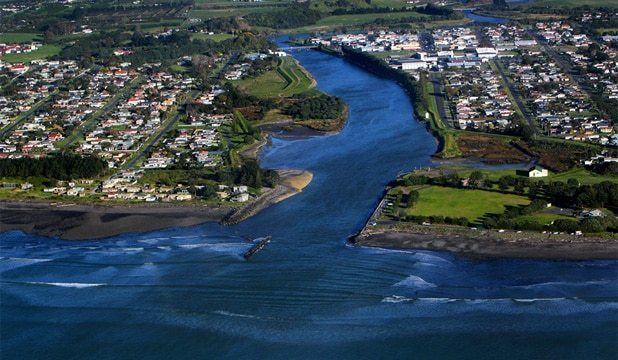
After the closure, the majority of buildings making up the Waitara freezing works were demolished, significantly changing the townscape (the area on the right on the far side of the river in the image of Waitara below, was the site of the freezing works).
ANZCO Foods Group subsequently built a plant to manufacture smallgoods such as salami, sausages and hamburger patties on the site of the freezing works. However, AFFCO went to court to enforce a 20-year encumbrance which restricts meat processing and associated activities on the site. It succeeded in both the High Court and the Court of Appeal in preventing the new plant from opening, although an ANZCO subsidiary was allowed to continue using freezer and coolstore facilities there. The two companies are said to have reached an agreement. ANZCO now operates from the site, and has become one of the major employers in the township.
Although the freezing works had been the economic backbone of Waitara, for over 75 years the plants had discharged blood, waste and effluent from the slaughter houses, chains and tanneries directly into the Waitara River, less than 3 km from the sea, well within the tidal zone.
Even after an ocean outfall was built in collaboration with the town council's sewerage system, at Waitangi Tribunal hearings in Waitara, local Maori gave evidence that they had "…historic associations with the coastline in this area and depend upon the sea resources to provide them with the diet to which they have been accustomed for many centuries…..thus the contamination of one reef would deprive hapu which customarily was entitled to the sea food from the reef".
Two large petrochemical plants are now the most important industrial activity in Waitara. The Waitara Valley plant is dedicated to production of methanol from natural gas (about 1500 tonnes per day). The Motunui plant, originally designed to produce synthetic petrol from methanol was modified to produce chemical grade methanol for export.
The high cost of synthetic petrol production and low market prices made the process uneconomical at the time. Motunui has the two largest wooden structures in the southern hemisphere and they are only exceeded in size, anywhere in the world, by the Buddhist temple Tōdai-ji in Nara, Japan. The Motunui plant was closed in December 2004, and restarted in 2008. An onshore production facility for the Pohokura oilfield has been built immediately adjacent to it.
The town continues to be a service centre for the farming sector, particularly to the north and northeast.
Farming in the Waitara catchment includes dairying, beef cattle for meat, sheep for both meat and wool, fruit—mainly kiwifruit—other horticulture including tree and shrub nurseries, and poultry for meat and eggs.
Education
Waitara High School is the only secondary (years 9-13) school in Waitara with a roll of 343. The school celebrated 60 years in 2007.
Manukorihi Intermediate is an intermediate (years 7-8) school with a roll of 196. It celebrated its 25th jubilee in 1999.
Waitara Central School and Waitara East School are contributing primary (years 1-6) schools with rolls of 116 and 251, respectively. Waitara Central celebrated its 125th jubilee in 2000.
St Joseph's School is a full primary (years 1-8) school with a roll of 161. It is a state integrated Catholic school.
All these schools are coeducational.