
Length 19 km Country United States of America | Source Alaka‘i Swamp | |
 | ||
- location Waimea, Kauai County, Hawaii | ||
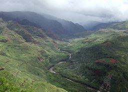
The Waimea River is a river on the island of Kauai in the U.S. state of Hawaii. At 12.1 miles (19.5 km) in length, it is one of the longest rivers in the Hawaiian Islands.
Map of Waimea River, Hawaii, USA
It rises in a wet plateau of the island's central highlands, in the Alaka'i Swamp, the largest high-elevation swamp in the world. It flows south, passing through the spectactular 3,000-foot-deep (910 m) Waimea Canyon, known as the "Grand Canyon of the Pacific."
The valleys of the Waimea River and its tributary, the Makaweli River, were once heavily populated. It enters the Pacific Ocean at Waimea, near the 1778 landing place of Captain Cook on Kauai.
References
Waimea River (Hawaii) Wikipedia(Text) CC BY-SA