
 | ||
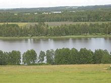
Vooremaa ("Drumlin Land" in Estonian) is a 977 km2 (377 sq mi) landscape region mostly in Jõgeva County, Estonia. It consists of drumlins and depressions that were formed by the glacial accumulation and erosion. All the landscape elements such as relief, vegetation, waterbodies and watercourses as well as settlements follow the northwest-southeast direction of the drumlins. The drumlins are 2–13 km (1.2–8.1 mi) long, 1–2 km (0.62–1.24 mi) wide and up to 70 m (230 ft) high. 47% of Vooremaa is cultivated and villages are located on the feet of the drumlins. One fifth (20.3%) of the area is covered by wetlands. The highest point is Laiuse drumlin, at 144 m (472 ft).
Map of Vooremaa, 49228 J%C3%B5geva County, Estonia
References
Vooremaa Wikipedia(Text) CC BY-SA