
- elevation 502 m (1,647 ft) - elevation 425.5 m (1,396 ft) Length 120 km Basin area 1,445 km² | - elevation 466 m (1,529 ft) - elevation 279 m (915 ft) Discharge 76.8 m³/s | |
 | ||
- location | ||
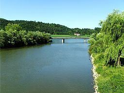
The Vils is a river in Bavaria, Germany, right tributary of the Danube. It is formed by the confluence of its two source rivers, the Kleine Vils and the Große Vils, in Gerzen. It is 68.62 km long (104 km including Große Vils). It flows east through a rural area with small towns, including Aham, Frontenhausen, Marklkofen, Reisbach, Eichendorf and Aldersbach. It flows into the Danube in Vilshofen.
Map of Vils, Germany
References
Vils (Danube) Wikipedia(Text) CC BY-SA