
Country United States FIPS code 35-83130 Elevation 1,789 m Local time Monday 8:27 AM Area code 505 | Time zone MST (UTC-7) GNIS ID 915912 Population 267 (2000) Zip code 87583 | |
 | ||
Weather 9°C, Wind W at 31 km/h, 52% Humidity | ||
Trip to villanueva new mexico
Villanueva is an Unincorporated community and census-designated place in San Miguel County, New Mexico, United States. It is located along the Pecos River and New Mexico State Highway 3. Villanueva has the ZIP code 87583. The 87583 ZIP Code Tabulation Area had a population of 267 at the 2000 census.
Contents
Map of Villanueva, NM, USA
History
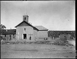
Villanueva, an old Spanish colonial village, was originally called La Cuesta (Spanish, hill or slope) because the village sits on top of a steeply sloping hill or cuesta in the Pecos Valley. Soon after the Spanish Government approved the San Miguel del Vado Land Grant in 1794, settlements were established along the banks of the Pecos River, such as Bernal, El Pueblo, Entrnosa, Guzano, La Cuesta, Las Mulas, Puertecito, San Jose, San Miguel.
Some Cibolero buffalo hunters of the 19th century originated from La Cuesta and other Hispano communities along the Pecos River.
In 1890, the community was renamed to Villanueva, for a prominent local family.
Area attractions
East of Villanueva is Villanueva State Park, a colorful canyon cut by the Pecos River.