
1863–2001 → Independence from the United Counties of Peterborough and Victoria 1863 | 1863 Patrick McHugh (first) | |
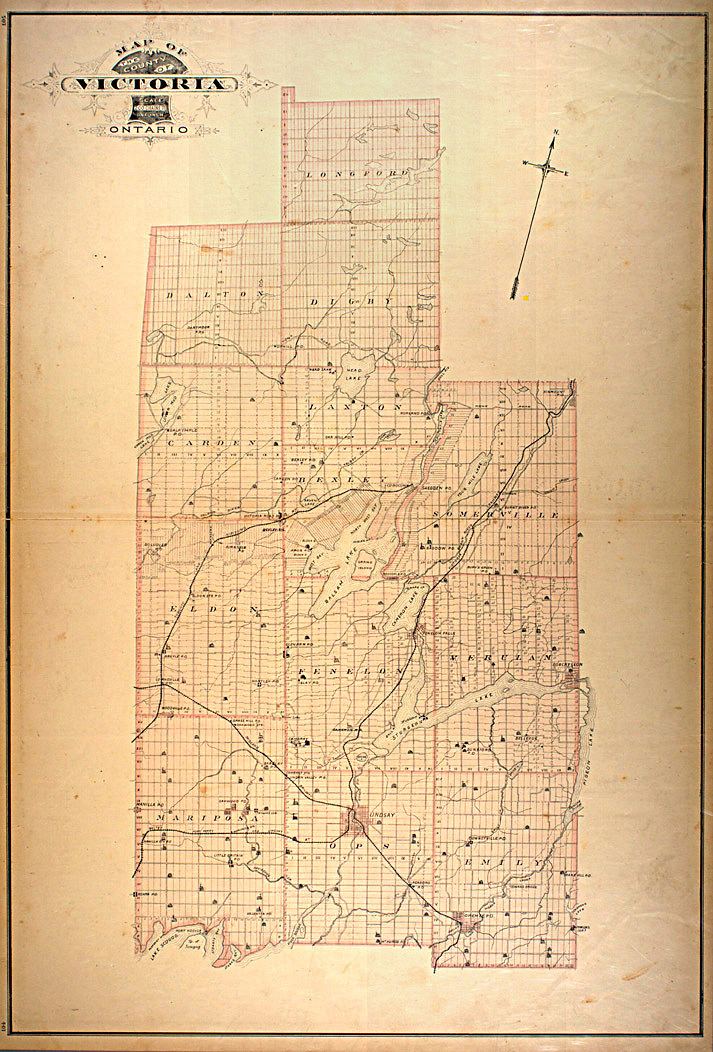 | ||
Political subdivisions ListEmily TownshipOps TownshipMariposa TownshipVerulam TownshipFenelon TownshipEldon TownshipSomerville TownshipBexley TownshipCarden TownshipLaxton, Digby and Longford TownshipDalton TownshipManvers Township | ||
The County of Victoria, or Victoria County, was a county in the Canadian province of Ontario. It was formed in 1854 as The United Counties of Peterborough and Victoria, and separated from Peterborough in 1863. In 2001, the county was dissolved and reformed as the City of Kawartha Lakes. Though first opened to settlement in 1821, the area that was encompassed by Victoria County has a history of Indian occupation, first by the Hurons.
Contents
History
The history of Victoria County began with the passing of the Constitutional Act in 1791, dividing Canada into two provinces: Upper Canada (present day Ontario) and Lower Canada (present day Québec); and appointing a governor for each. The first governor of Upper Canada was Colonel John Graves Simcoe, who surveyed the province and set out tracts of land for immigrants with genuine interests. Before the land that became Victoria County could be surveyed, however, speculators had Simcoe removed from office in 1796, and the land was secured from settlement for over 20 years.
Following the War of 1812, a large wave of immigration prompted the province to purchase more land from local Indian tribes. On 5 November 1818, six Mississauga chiefs, Buckquaquet of the Eagles, Pishikinse of the Reindeers, Paudash of the Cranes, Cahgahkishinse of the Pike, Cahgageewin of the Snakes, and Pininse of the White Oaks, met in Port Hope. There they surrendered the rights to over four thousand square kilometres of land, known as the Mississauga Tract. In exchange, the Indians (numbering about 400) were to receive $750 per year in goods. However, the government later changed this to $10 per year for each living person born before the deal was signed.
The Mississauga Tract included all of Victoria and Peterborough counties, as well as parts of 28 adjacent townships. Following the purchase, the land became Newcastle District. It was renamed Colborne District in 1841, followed by being reorganized in 1850 as Peterborough County. In 1854, Peterborough County was again reorganized as the United Counties of Peterborough and Victoria, the first time the land was officially named "Victoria County". Over the next decade, Victoria County gradually separated from Peterborough County, gaining a provisional government in 1861, and finally independence in 1863.
In 1973, Manvers Township was transferred from Durham County (Now the Regional Municipality of Durham) to Victoria County as a result of the restructuring of several county governments.
On 1 January 2001, Victoria County was dissolved, and its townships and incorporated communities were amalgamated into a single-tier municipality named Kawartha Lakes, a name chosen because of the prominence of the lakes in the geography of the region.
Geography
It encompassed 2,855.56 square kilometres (1,102.54 sq mi)
Townships
Victoria County consisted of 13 separate townships and 6 incorporated villages with their own local governments. Population centres are listed in parentheses:
The township of Laxton, Digby and Longford is an amalgamation of the once individual townships of Digby and Laxton, and half of the original Longford Township. The separate township of Longford is uninhabited, though dotted with abandoned logging towns.
Incorporated communities
Abandoned towns, post offices and church villages
Demographics
+ Census Canada
The population is mostly rural, with only 34% living in urban areas.
Colonization roads
Victoria County was first opened up to settlement in the 1821. At this time, the primary routes for entering the county-to-be were narrow trails. Settlers were offered land on the condition that they help further the progress of concession roads into the region. This was often met with the bare minimum, and progress was slow.
The Land Act of 1853 provided funding for the development of roads throughout the wilderness of Upper Canada. Grants were administered by the Department of Agriculture to survey and build the new roads. The roads followed the tradition of old Roman roads, and cut through the wilderness in a straight line, veering only when the terrain was impassable, but cutting through swamps and hills otherwise. Four primary roads were built: the Cameron Road, the Bobcaygeon Road, the Monck Road, and the Portage Road.
http://www.ontariogenealogy.com/Victoria/settleme.html http://www.ontariogenealogy.com/Victoria/history/victoriacountypioneers2.html
The Cameron road, now mostly encompassed by Highway 35, provided access from Lake Ontario to the northern limits of Victoria;
The Bobcaygeon Road, begun in 1853, traversed north and south along the present-day eastern boundary of the region, and is mostly encompassed by former Highway 121;
The Monck Road, which connected Lake Couchiching to Bancroft, encompassed partially by former Highway 503, now City Road 45;
The Portage Road, connecting Lake Simcoe to Balsam Lake, encompassed entirely by former Highway 48, now City Road 48
Waterways
The Trent Severn canal system crosses what used to be the Northern part of Victoria County. It passes through Sturgeon lake and the city of Bobcaygeon. The canal is connected to Lake Scugog by the Scugog river which passes through Lindsay.
Economy
Agriculture and tourism (cottages / summer homes) dominated the economy while this region existed.
Education
At one time the Victoria County Board of Education provided educational services. In 1999 it was amalgamated into the Trillium Lakelands District School Board.