
Traditional Chinese 維多利亞城 IPA [wɐ̏itɔ́ːlèiʔā si̬] | Yale Romanization Wàih dō leih a síh Jyutping Wai do lei aa si | |
 | ||
Weather 18°C, Wind NE at 16 km/h, 64% Humidity | ||
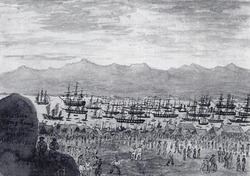
Victoria, officially the City of Victoria, was one of the first urban settlements in Hong Kong after it became a British colony in 1842. It was initially named Queenstown but was soon known as Victoria. It served as the de facto capital of Hong Kong during the British colonial period, and almost all government departments still have their head offices located within its limit.
Contents
Present-day Central is at the heart of Victoria City. Although the city expanded over much of what is now Kennedy Town, Sheung Wan, and Wan Chai, the name Victoria has been eclipsed by Central in popular usage. However, the name is still used in places such as Victoria Park, Victoria Peak, Victoria Harbour, Victoria Prison, and a number of roads and streets. It is also retained in the names of various organisations such as the Victoria City District of the Hong Kong Scout, and the Victoria Junior Chamber. The name Victoria District Court had been used into the 1980s, when it was moved to the Wanchai Tower and combined with other district courts in the territory.
Location
The city is centred in present-day Central, and named after Queen Victoria in 1843. It occupies the areas known in modern times as Central, Admiralty, Sheung Wan, Wan Chai, East Point, Shek Tong Tsui, the Mid-levels, the Peak, Happy Valley, Tin Hau, and Kennedy Town, on Hong Kong Island. In 1903, the Hong Kong Government erected seven boundary stones for the city, inscribed "City Boundary 1903" at Hatton Road (克頓道), Pok Fu Lam Road, Bowen Road, Old Peak Road (舊山頂道), Wong Nai Chung Road, Victoria Road/Sai Ning Street (西寧街) and Magazine Gap Road. All remain, except for the one in Magazine Gap Road, which disappeared around mid-June 2007.
History
In 1857, the British government expanded the scope of Victoria City and divided it into four "wans" (環, jyutping: waan4, pinyin: huán, literally rings). The four wans are Sai Wan ("West Ring" in Chinese, present-day Sai Wan, including Kennedy Town, Shek Tong Tsui, and Sai Ying Pun), Sheung Wan ("Upper Ring" in Chinese, present-day Sheung Wan), Choong Wan or Chung Wan ("Central Ring" in Chinese, present-day Central) and Ha Wan ("Lower Ring" in Chinese, present-day Wan Chai). Except "Ha Wan"; "Sai Wan", "Sheung Wan" and "Choong Wan" retain the same name in Chinese today.
The four wans are further divided into nine "yeuks" (約, jyutping: joek3, pinyin: yuē, similar to "district" or "neighbourhood"). The coverage also included parts of East Point and Happy Valley (West of Wong Nai Chung Road on the east side of the Racecourse). In 1903, boundary stones were established to mark the City's boundary and six of them are still preserved today. The stones spread from Causeway Bay to Kennedy Town.
In the 1890s the capital city extended four miles west to east along the coastal strip. Buildings were made of granite and brick. Buses and the new tramway would become the main form of transportation in the area.
Districts
Also called yeuks.