
Airport type Public Elevation AMSL 647 ft / 197 m 2,940 896 Elevation 197 m | Owner City of Vernonia 9/27 2,940 896 Turf Serves Vernonia | |
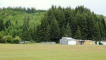 | ||
Vernonia Municipal Airport (FAA LID: 05S) is a city-owned, public-use airport located two nautical miles (3.7 km) west of the central business district of Vernonia, a city in Columbia County, Oregon, United States.
Facilities and aircraft
Vernonia Municipal Airport covers an area of 47 acres (19 ha) at an elevation of 647 feet (197 m) above mean sea level. It has one runway designated 9/27 with a turf surface measuring 2,940 by 45 feet (896 x 14 m).
For the 12-month period ending February 12, 2007, the airport had 3,000 general aviation aircraft operations, an average of 250 per month. At that time there were 5 aircraft based at this airport, all single-engine.
References
Vernonia Municipal Airport Wikipedia(Text) CC BY-SA