
Population 662 (2011 census) Postal code 5245 | Postcode(s) 5245 Local time Sunday 5:05 PM | |
 | ||
Weather 14°C, Wind SE at 18 km/h, 52% Humidity | ||
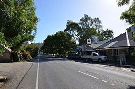
Verdun is a small town in the Adelaide Hills, Australia, on the road from Hahndorf to Balhannah. At the 2011 Australian Census the town recorded a population of 662.
Map of Verdun SA 5245, Australia
Verdun is approximately 4 km from Hahndorf and 5 km from Bridgewater. There is one school, one pub and a licensed café/restaurant situated in the building previously occupied by a service station and general store..
Verdun originally had the German name Grunthal, after being named by the Prussian settlers who established the town. The town was renamed in 1917 after one of the bloodiest battles of the First World War, the Battle of Verdun.
The Hills Christian Community School opened in February 1983 at the site of the former Verdun Primary School.
References
Verdun, South Australia Wikipedia(Text) CC BY-SA