
Country United States Demonym(s) Vegalteños Area 71.87 km² Population 40,100 (2011) Mayor Oscar Santiago (PPD) | Founded 1775 Time zone AST (UTC-4) Zip code 00692 Unemployment rate 11.9% (Apr 2015) Rivers Río Cibuco, Mavilla River | |
 | ||
Points of interest Parque Nacional de Cerro, Vega Alta State Park, Balneario Cerro Gordo, Playa de Cerro Gordo | ||
Vega Alta ([ˈbeɣa ˈalta], Upper Riverplain) is a municipality of Puerto Rico. Vega Alta is located on the northern coast of the island, north of Morovis and Corozal; east of Vega Baja; and west of Dorado with an area of 28 square miles (73 km2). Vega Alta is spread over seven wards and Vega Alta Pueblo (the downtown area and the administrative center of the city). It is part of the San Juan-Caguas-Guaynabo Metropolitan Statistical Area.
Contents
- Map of Vega Alta Puerto Rico
- History
- Geography
- Climate
- Agriculture
- Industry
- Sports
- Music
- Festivals and events
- Demographics
- Government
- Past and present mayors
- Transportation
- Public schools
- Middle School
- Private schools
- References
Map of Vega Alta, Puerto Rico
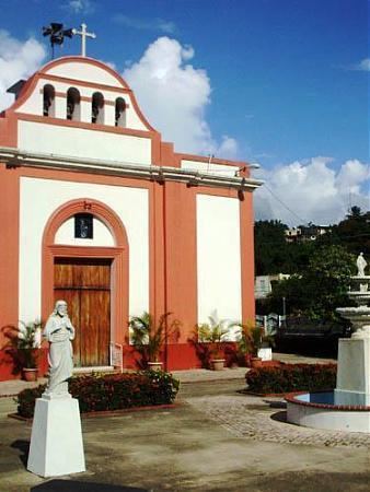
Vega Alta is west of San Juan, the capital of Puerto Rico. Vega Alta is known for the beach at Cerro Gordo. Other points of interest include the town's Catholic church, known as Inmaculada Concepción, founded in 1813, and the Vega Alta Forest.
During the first week of December, Vega Alta celebrates its patron, The Immaculate Conception.
History
Vega Alta was founded in 1775 by Francisco de los Olivos. It was first named La Vega de Espinosa and known as el pueblo de los Ñangotaos ("the squatters", in reference to the "jíbaros" country folk who would squat due to lack of benches to wait for the train). Before this it was part of a group of towns known as "Las Vegas." It was then that one area was named Vega Baja and the other Vega Alta.
On October 12, 1898 the city's mayor, Francisco Vega, received U.S. troops as part of the Spanish–American War. On that same day, for the first time in Vega Alta's history, the U.S. flag was lifted on city hall. From 1902 to 1905, Vega Alta became once more part of the neighbor city of Vega Baja. In 1905, the government of Puerto Rico passed a law, allowing Vega Alta to become a municipality with its own limits.
Geography
Climate
According to the Weather Channel's website, June is the warmest month, March is the coolest month, October is the wettest month, and June is the driest month. Records:
Agriculture
Industry
Sports
Vega Alta Maceteros (Double A Baseball League)
Vega Alta is known for having amateur ball players as well as professional. Basketball is played in local communities. Other sports practiced include tennis, volleyball, handball, cock fighting, and amateur surfing among others.
Vega Alta is also known for having famous Major League Baseball players such as The Molina Brothers which consist of Yadier Molina, Bengie Molina and José Molina. Other famous sport personalities include former New York Yankees center fielder Bernie Williams and professional boxer Ángel Chacón.
Music
A well known musician from Vega Alta was Ladislao Martinez a.k.a. "El Maestro Ladi" (June 27, 1898–February 1, 1979), a master cuatro musician. He became the first Puerto Rican to play a cuatro solo on the radio.
Fiel a la Vega, a rock en español (rock in Spanish) band, was formed in 1994. Band members Tito Auger and Ricky Laureano are from Vega Alta, while brothers Pedro Arraiza and Jorge Arraiza come from next-door Vega Baja. Their first album spawned hits like "Salimos de Aquí" and "El Wanabí", both of which were released with videos.
The Puerto Rican musician and playwright Lin-Manuel Miranda is from a family with roots in Vega Alta and has made frequent visits. http://www.nbcnews.com/news/latino/lin-manuel-miranda-s-puerto-rican-town-crisis-worries-family-n565371
Festivals and events
Demographics
Government
The main women's prison of the Puerto Rico Department of Corrections and Rehabilitation, Escuela Industrial para Mujeres in Vega Alta, opened in 1954, replacing a prison in Areceibo; work began on the facility in 1952. Puerto Rico also operates the Hogar de Adaptación Social en Vega Alta, which opened in 1987.
Past and present mayors
Transportation
Puerto Rico's Highway 22 provides access to Vega Alta from the far away city of Mayaguez, or from San Juan. Highway 2 also provides access from the western cities of Manatí, Arecibo and the eastern cities of Bayamón and Guaynabo bordering the shore to the Atlantic Ocean. It takes approximately 30 minutes to reach the town from San Juan.