
Elevation 1,610 m | Prominence 425 m | |
 | ||
Easiest route Start from the settlement of Štefanová (625 m), go through the pass of Medziholie (1,185 m) and follow the green trail (green blazes) to the summit. The ascent takes about two and a half hours. Similar Malý Rozsutec, Veľký Kriváň, Stoh, Chleb, Poludňový grúň | ||
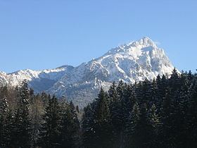
Veľký Rozsutec (1,609.7 m; 5,281.17 ft AMSL) is a mountain situated in the Malá Fatra mountain range in the Žilina Region, Slovakia. The peak is situated in the north part of Malá Fatra called Krivánska Malá Fatra and is part of the Malá Fatra National Park and Rozsutec National Nature Reserve (since 1967).
Map of Ve%C4%BEk%C3%BD Rozsutec, 013 06 Terchov%C3%A1, Slovakia
Veľký Rozsutec and the surrounding area are home to many endangered species of plants and animals, some of which are endemic, as well as rare karst terrain.
References
Veľký Rozsutec Wikipedia(Text) CC BY-SA